IMAGES TAKEN NEAR TO
Brookvale Road, SOUTHAMPTON, SO17 1QR
Introduction
This page details the photographs taken nearby to Brookvale Road, SO17 1QR by members of the Geograph project.
The Geograph project started in 2005 with the aim of publishing, organising and preserving representative images for every square kilometre of Great Britain, Ireland and the Isle of Man.

There are currently over 7.5m images from over14,400 individuals and you can help contribute to the project by visiting https://www.geograph.org.uk
Image Map
Images are licensed for reuse under creativecommons.org/licenses/by-sa/2.0
Notes
- Clicking on the map will re-center to the selected point.
- The higher the marker number, the further away the image location is from the centre of the postcode.
Image Listing (42 Images Found)
Images are licensed for reuse under creativecommons.org/licenses/by-sa/2.0
Image
Details
Distance
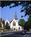
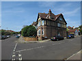
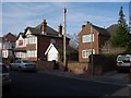
1
Building on Brookvale Road, Southampton
Dated 1922, a long symmetrical range of houses, looking like they were built as something else, but there is no evidence they were.
Image: © Robin Webster
Taken: 16 Sep 2018
0.06 miles
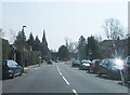
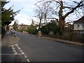
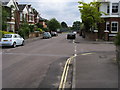
2
Slightly odd sign
The no through road has been added to try to indicate that this set of roads doesn't link to The Avenue (unless you're on foot or on a bike). The residents got very annoyed that people were driving too fast in the area trying to use it as a rat run so wanted the sign. Having cycled through it for almost three years, I could recognise most of the cars that drove too fast as they were residents'. Never mind, it gave them something to worry about.
Image: © Hugh Venables
Taken: 4 Feb 2007
0.08 miles
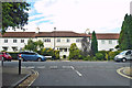
3
Woodstock Drive, Highfield, Southampton
Imposing property on the corner with more large family homes behind.
Image: © Hugh Venables
Taken: 27 Jan 2007
0.08 miles
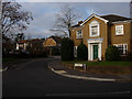
4
Traffic calming
These narrowings make it hard for two cars to pass and do actually work to slow traffic. The narrow mouth to the road though is just a pain as hard to turn in if another car is waiting to pull out.
Image: © Hugh Venables
Taken: 4 Feb 2007
0.08 miles
5
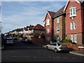
Oakmount Avenue
Relatively new, purpose built, flats on the corner, then large detached houses which look like inter-war developments (certainly present by 1940).
Image: © Hugh Venables
Taken: 4 Feb 2007
0.14 miles
7
Heatherdeane Road
Heatherdeane Road passing Khartoum Road
Image: © Shaun Ferguson
Taken: 31 May 2008
0.18 miles
8
Infill house
The house on the right is presumably post-war infilling of bomb damage - the housing along the road is mostly from before WW2. It is noticeably smaller and plainer, probably reflecting the reality of the time to built a lot of housing and infrastructure with limited resources.
Image: © Hugh Venables
Taken: 4 Feb 2007
0.19 miles