IMAGES TAKEN NEAR TO
Brookvale Road, SOUTHAMPTON, SO17 1PW
Introduction
This page details the photographs taken nearby to Brookvale Road, SO17 1PW by members of the Geograph project.
The Geograph project started in 2005 with the aim of publishing, organising and preserving representative images for every square kilometre of Great Britain, Ireland and the Isle of Man.

There are currently over 7.5m images from over14,400 individuals and you can help contribute to the project by visiting https://www.geograph.org.uk
Image Map
Images are licensed for reuse under creativecommons.org/licenses/by-sa/2.0
Notes
- Clicking on the map will re-center to the selected point.
- The higher the marker number, the further away the image location is from the centre of the postcode.
Image Listing (45 Images Found)
Images are licensed for reuse under creativecommons.org/licenses/by-sa/2.0
Image
Details
Distance
1
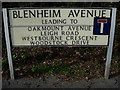
Slightly odd sign
The no through road has been added to try to indicate that this set of roads doesn't link to The Avenue (unless you're on foot or on a bike). The residents got very annoyed that people were driving too fast in the area trying to use it as a rat run so wanted the sign. Having cycled through it for almost three years, I could recognise most of the cars that drove too fast as they were residents'. Never mind, it gave them something to worry about.
Image: © Hugh Venables
Taken: 4 Feb 2007
0.11 miles
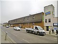
2
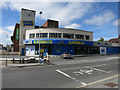
Former Blockbuster, Portswood
Someone has helpfully sprayed 'Pirate Bay' onto the window, this being one of the file-sharing websites that allowed users to access films online for free rather than paying to buy or rent them from a high street shop. Blockbuster are still operating (just) but have closed many of their shops. The planning notice related to Morrisons, who were taking over the site, requesting a licence to sell alcohol.
Image: © Hugh Venables
Taken: 5 May 2013
0.12 miles
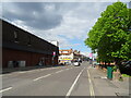
3
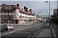
Portswood Road
Portswood Road looking north with the entrance to Brookvale Road on the left
Image: © David Mainwood
Taken: 4 Jul 2005
0.13 miles
4
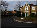
Woodstock Drive, Highfield, Southampton
Imposing property on the corner with more large family homes behind.
Image: © Hugh Venables
Taken: 27 Jan 2007
0.13 miles
6
Portswood, supermarket
Waitrose, on Portswood Road. http://www.waitrose.com/bf_home/bf/720.html
Image: © Mike Faherty
Taken: 9 Dec 2016
0.13 miles
7
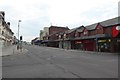
Shops on Portswood Road
A line of shops on Portswood Road including Subway and Pizza Hut. This is the junction with Brookvale Road.
Image: © DS Pugh
Taken: 25 Aug 2016
0.13 miles
9
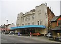
Portswood, Victory Gospel Church
On Portswood Road. The building was formerly the Broadway Cinema, from the 1930s to 1963; latterly a bingo hall, till 2010; now a church. http://cinematreasures.org/theaters/21344 https://www.facebook.com/pages/The-Victory-Centre/108630309231901
Image: © Mike Faherty
Taken: 9 Dec 2016
0.14 miles
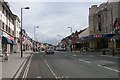
10
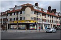
Addis Square, Portswood
The building housing shops is named Addis Square and stands on Portswood Road in Portswood, Southampton.
Image: © Philip Halling
Taken: 28 Jun 2014
0.15 miles