IMAGES TAKEN NEAR TO
Crabwood Road, SOUTHAMPTON, SO16 9GD
Introduction
This page details the photographs taken nearby to Crabwood Road, SO16 9GD by members of the Geograph project.
The Geograph project started in 2005 with the aim of publishing, organising and preserving representative images for every square kilometre of Great Britain, Ireland and the Isle of Man.

There are currently over 7.5m images from over14,400 individuals and you can help contribute to the project by visiting https://www.geograph.org.uk
Image Map
Images are licensed for reuse under creativecommons.org/licenses/by-sa/2.0
Notes
- Clicking on the map will re-center to the selected point.
- The higher the marker number, the further away the image location is from the centre of the postcode.
Image Listing (24 Images Found)
Images are licensed for reuse under creativecommons.org/licenses/by-sa/2.0
Image
Details
Distance
1
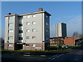
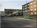
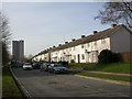
Social housing
High, medium and low-rise housing in the north-western suburbs of Southampton.
Compare and contrast with Image taken over 13 years earlier.
Image: © Jonathan Billinger
Taken: 17 Feb 2010
0.09 miles
2
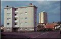
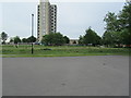
Flats in Ennerdale Road
The taller block in the distance is Millbrook Towers on Windermere Avenue. The scene is typical of this large local authority-built housing estate.
Image: © David Martin
Taken: Unknown
0.10 miles
3
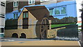
Clever wall art on tower block
I think it's really clever the way this wall art has been done on Millbrook towers
Image: © J W Parker
Taken: 12 Aug 2012
0.12 miles
4
Millbrook Towers art
I love all the wall art around Millbrook Towers, but this particular section the way it includes the flat windows into the art is very clever in my opinion.
Image: © J W Parker
Taken: 12 Aug 2012
0.12 miles
5
Maybush, shopping parade
At the junction of Windermere Avenue & Green Lane; from the right, bridal wear, pet grooming, newsagent, pizzas, pharmacy, betting, convenience store.
Image: © Mike Faherty
Taken: 2 Mar 2010
0.12 miles
6
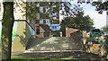
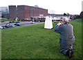
Mansel park and Millbook towers
Looking across the old basketball court in Mansel park up towards Millbrook towers
Image: © J W Parker
Taken: 17 Jun 2013
0.12 miles
7
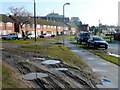
Maybush Road, Southampton
The grassy verges have been well-used as overflow parking in this area of 1950's social housing.
The large building beyond is the (soon to be) old OS headquarters building.
Image: © Jonathan Billinger
Taken: 17 Feb 2010
0.15 miles
9
Maybush, terraced housing
On Windermere Avenue; Millbrook Tower in the distance to the left.
Image: © Mike Faherty
Taken: 2 Mar 2010
0.16 miles
10
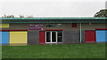
Millbrook Community Library at the MP3 centre at Mansel park
Millbrook library which used to be at Cumbrian way, and before that in Sedbergh rd, is now in the MP3 centre at Mansel Park. It is easy to miss as you have to go around the back of the building. The centre has computers with internet access and some books. They also offer a free service where you can order books from any other library and have them delivered to Millbrook.
Image: © J W Parker
Taken: 11 Oct 2013
0.16 miles