IMAGES TAKEN NEAR TO
University Parkway, SOUTHAMPTON, SO16 7QQ
Introduction
This page details the photographs taken nearby to University Parkway, SO16 7QQ by members of the Geograph project.
The Geograph project started in 2005 with the aim of publishing, organising and preserving representative images for every square kilometre of Great Britain, Ireland and the Isle of Man.

There are currently over 7.5m images from over14,400 individuals and you can help contribute to the project by visiting https://www.geograph.org.uk
Image Map
Images are licensed for reuse under creativecommons.org/licenses/by-sa/2.0
Notes
- Clicking on the map will re-center to the selected point.
- The higher the marker number, the further away the image location is from the centre of the postcode.
Image Listing (24 Images Found)
Images are licensed for reuse under creativecommons.org/licenses/by-sa/2.0
Image
Details
Distance
1
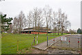
Chilworth Research Centre
Seen from stub end of Manor Road. This is only one of several buildings comprising this centre.
Image: © Peter Facey
Taken: 11 Mar 2009
0.05 miles
2
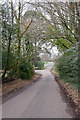
Manor Road, Chilworth
Where it turns left, the road changes into Chilworth Drove. Straight ahead is Chilworth Research Centre, a science park set up by Southampton University in 1984.
Image: © Peter Facey
Taken: 11 Mar 2009
0.06 miles
3
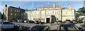
Chilworth Manor
Chilworth Manor is a hotel, wedding venue and conference centre adjoining the University of Southampton Science Park in the village of Chilworth to the north of the city of Southampton.
It was built in the early years of the C20th and contains a remarkable central hall which is the full height of the hotel.
Their website: https://www.chilworthmanorhotel.com
Note: The slight apparent curvature is a result of the panoramic photograph, the frontage is in fact entirely straight.
Image: © Rob Farrow
Taken: 28 Aug 2022
0.12 miles
4
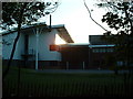
Chilworth Science Park
Part of Chilworth Science Park, a high-tech research and development facility.
Image: © GaryReggae
Taken: 12 Jul 2005
0.15 miles
5
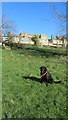
Path through the Orchard leading to Chilworth manor Hotel
There is a lovely conservation area besides Chilworth Manor hotel, this is the path through the Orchard that leads up the steps to the formal garden in front of the hotel.
Image: © J W Parker
Taken: 1 Mar 2014
0.15 miles
6
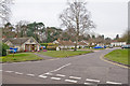
Chilworth Close
A residential cul de sac off Manor Road. The bungalow on the left has been made into a shop, see Image
Image: © Peter Facey
Taken: 11 Mar 2009
0.19 miles
7
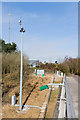
Masts and Telecoms equipment beside Chilworth Drove
On the northern bank of the M27 after recent widening work. The green thing in the foreground is a traffic sensor mounted on the bridge. Buildings beyond are within Chilworth Research Centre.
Image: © Peter Facey
Taken: 11 Mar 2009
0.19 miles
8
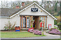
Chilworth Store, Chilworth Close
This appears to be a bungalow that has been made into a shop. For a wider view see Image
Image: © Peter Facey
Taken: 11 Mar 2009
0.20 miles
9
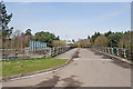
Bridge carrying Chilworth Drove over M27
Buildings on far side are within Chilworth Research Centre.
Image: © Peter Facey
Taken: 11 Mar 2009
0.20 miles
10
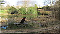
Small stone bench by the lake in Chilworth Conservation area
A lovely stone bench makes an ideal place to stop by the lake in the Chilworth Conservation area, a very beautiful place. http://chilworthconservation.co.uk/history
Image: © J W Parker
Taken: 1 Mar 2014
0.21 miles