IMAGES TAKEN NEAR TO
Bassett Crescent East, SOUTHAMPTON, SO16 7PB
Introduction
This page details the photographs taken nearby to Bassett Crescent East, SO16 7PB by members of the Geograph project.
The Geograph project started in 2005 with the aim of publishing, organising and preserving representative images for every square kilometre of Great Britain, Ireland and the Isle of Man.

There are currently over 7.5m images from over14,400 individuals and you can help contribute to the project by visiting https://www.geograph.org.uk
Image Map
Images are licensed for reuse under creativecommons.org/licenses/by-sa/2.0
Notes
- Clicking on the map will re-center to the selected point.
- The higher the marker number, the further away the image location is from the centre of the postcode.
Image Listing (32 Images Found)
Images are licensed for reuse under creativecommons.org/licenses/by-sa/2.0
Image
Details
Distance
1
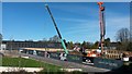
Development of the new National Infrastructure Laboratory, University of Southampton
Image: © David Martin
Taken: 13 Mar 2017
0.08 miles
2

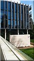
Biomedical science building
University of Southampton's biomedical science building, currently being redeveloped.
Image: © Nick Smith
Taken: 3 Jul 2010
0.10 miles
3
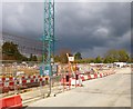
Bassett, building site
Seen from Burgess Road; according to a notice, to be Southampton University's Maritime Centre of Excellence: http://www.southampton.ac.uk/estatedevelopment/projects/mce.html
Image: © Mike Faherty
Taken: 21 Apr 2012
0.11 miles
4
Boldrewood Campus
Boldrewood Campus University of Southampton
Image: © Shaun Ferguson
Taken: 16 Aug 2008
0.12 miles
5
University of Southampton Building 176
Part of the Boldrewood Innovation Campus.
Image: © David Martin
Taken: 13 Mar 2017
0.14 miles
6
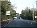
A33 Bassett Avenue heading north
A busy road linking to the M3 from the city centre.
Image: © Robin Webster
Taken: 16 Sep 2018
0.16 miles
8
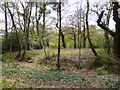
Southampton Common, Cutthorn
A mound with levelled top next to Burgess Road; trees have been cleared to allow a better view. According to an interpretation board, the site of an annual moot, meeting on the third Tuesday after Easter. Listed by Pastscape: http://www.pastscape.org.uk/hob.aspx?hob_id=230073&sort=2&rational=m&recordsperpage=10&maplat=50.93552729&maplong=-1.40435360&mapisa=1000&mapist=os&mapilo=-1.4044&mapila=50.9355&mapiloe=w&mapilan=n&mapios=SU418153&mapigrn=115350&mapigre=441850&mapipc=#aRt
Image: © Mike Faherty
Taken: 21 Apr 2012
0.18 miles
9
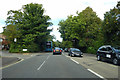
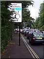
Glen Eyre Road
Seen from next to the junction with Burgess Road.
Image: © DS Pugh
Taken: 26 Aug 2016
0.18 miles
10
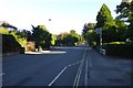
A33, Winchester Road roundabout, Southampton
A33, approaching the Winchester Road roundabout northbound, Southampton. A typical evening rush hour scene.
Image: © Steve Rigg
Taken: 4 Jul 2005
0.19 miles