IMAGES TAKEN NEAR TO
Chilworth Road, SOUTHAMPTON, SO16 7JX
Introduction
This page details the photographs taken nearby to Chilworth Road, SO16 7JX by members of the Geograph project.
The Geograph project started in 2005 with the aim of publishing, organising and preserving representative images for every square kilometre of Great Britain, Ireland and the Isle of Man.

There are currently over 7.5m images from over14,400 individuals and you can help contribute to the project by visiting https://www.geograph.org.uk
Image Map
Images are licensed for reuse under creativecommons.org/licenses/by-sa/2.0
Notes
- Clicking on the map will re-center to the selected point.
- The higher the marker number, the further away the image location is from the centre of the postcode.
Image Listing (7 Images Found)
Images are licensed for reuse under creativecommons.org/licenses/by-sa/2.0
Image
Details
Distance
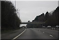
1

A27 Chilworth Road, Chilworth
Heading towards Romsey.
Image: © Robin Webster
Taken: 16 Sep 2018
0.19 miles
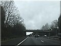
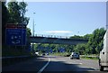
4
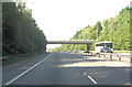
M27 bridge carries A27
At this point the A27 is called Chilworth Road and it links Romsey with the northern suburbs of Southampton.
Image: © Stuart Logan
Taken: 15 Sep 2011
0.21 miles