IMAGES TAKEN NEAR TO
Green Lane, SOUTHAMPTON, SO16 7JW
Introduction
This page details the photographs taken nearby to Green Lane, SO16 7JW by members of the Geograph project.
The Geograph project started in 2005 with the aim of publishing, organising and preserving representative images for every square kilometre of Great Britain, Ireland and the Isle of Man.

There are currently over 7.5m images from over14,400 individuals and you can help contribute to the project by visiting https://www.geograph.org.uk
Image Map
Images are licensed for reuse under creativecommons.org/licenses/by-sa/2.0
Notes
- Clicking on the map will re-center to the selected point.
- The higher the marker number, the further away the image location is from the centre of the postcode.
Image Listing (6 Images Found)
Images are licensed for reuse under creativecommons.org/licenses/by-sa/2.0
Image
Details
Distance
2
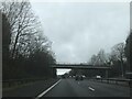
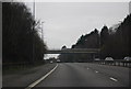
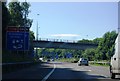
M27 bridge carries A27
At this point the A27 is called Chilworth Road and it links Romsey with the northern suburbs of Southampton.
Image: © Stuart Logan
Taken: 15 Sep 2011
0.12 miles
5
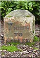
Old Milestone by the A27, Knightswood House, Chilworth parish
Metal plate attached to stone post by the A27, in parish of CHILWORTH (TEST VALLEY District), opposite Heatherlands Road, outside Knightswood House, on grass verge, on East side of road. Botley plate, erected by the Botley turnpike trust in the 19th century.
Inscription reads:-
7
MILES
TO
BOTLEY
(5)
(TO)
(ROMSEY)
Carved bench mark and rivet on top.
Grade II listed.
List Entry Number: 1093662 https://historicengland.org.uk/listing/the-list/list-entry/1093662
Milestone Society National ID: HA_BORO07.
Image: © K Lawrence
Taken: 26 May 2003
0.17 miles
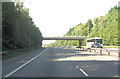
6
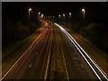
The night motorway
M27 motorway looking west at night.
Image: © Robin Baker
Taken: 29 Jan 2009
0.24 miles