IMAGES TAKEN NEAR TO
Roman Road, SOUTHAMPTON, SO16 7HE
Introduction
This page details the photographs taken nearby to Roman Road, SO16 7HE by members of the Geograph project.
The Geograph project started in 2005 with the aim of publishing, organising and preserving representative images for every square kilometre of Great Britain, Ireland and the Isle of Man.

There are currently over 7.5m images from over14,400 individuals and you can help contribute to the project by visiting https://www.geograph.org.uk
Image Map
Images are licensed for reuse under creativecommons.org/licenses/by-sa/2.0
Notes
- Clicking on the map will re-center to the selected point.
- The higher the marker number, the further away the image location is from the centre of the postcode.
Image Listing (18 Images Found)
Images are licensed for reuse under creativecommons.org/licenses/by-sa/2.0
Image
Details
Distance
1
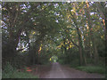
Route of a Roman road through Chilworth towards Bassett
View taken looking southeast uphill, this lane is called 'Roman Road' and is suitably straight. The tall trees either side of the lane are at the edge of the large detached houses commonly found in this part of Bassett.
Image: © Jim Champion
Taken: 12 Jul 2005
0.08 miles
2
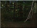
Woods near Chilworth Common
Woods near Chilworth Common
Image: © GaryReggae
Taken: 12 Jul 2005
0.08 miles
3
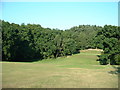
Looking towards Chilworth Common
Looking towards Chilworth Common from the NE extent of Southampton Golf Course.
Image: © GaryReggae
Taken: 12 Jul 2005
0.08 miles
4
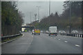
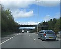
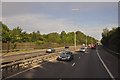
Test Valley : M27 Motorway
The M27 Motorway at Junction 4 (Chilworth Interchange).
Image: © Lewis Clarke
Taken: 28 Mar 2018
0.08 miles

8
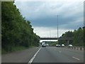
Two-lane link motorway between the east and west M27
View east from the bridge over the M27 in the middle of the grid square.
Image: © Jim Champion
Taken: 12 Jul 2005
0.13 miles
9
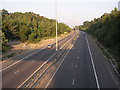
Southampton : The M27 Motorway
The M27 Motorway in Southampton at 8:03am.
Image: © Lewis Clarke
Taken: 23 Aug 2012
0.16 miles
10
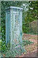
Unusual utilities cabinet outside house named Dunwoodie
There seems to be an heraldic shield in the centre of its front. The back is removable by key. The colouring being poised between blue and green gives little clue to its purpose.
Image: © Peter Facey
Taken: 30 Oct 2008
0.20 miles