IMAGES TAKEN NEAR TO
Chalybeate Close, SOUTHAMPTON, SO16 6UY
Introduction
This page details the photographs taken nearby to Chalybeate Close, SO16 6UY by members of the Geograph project.
The Geograph project started in 2005 with the aim of publishing, organising and preserving representative images for every square kilometre of Great Britain, Ireland and the Isle of Man.

There are currently over 7.5m images from over14,400 individuals and you can help contribute to the project by visiting https://www.geograph.org.uk
Image Map
Images are licensed for reuse under creativecommons.org/licenses/by-sa/2.0
Notes
- Clicking on the map will re-center to the selected point.
- The higher the marker number, the further away the image location is from the centre of the postcode.
Image Listing (101 Images Found)
Images are licensed for reuse under creativecommons.org/licenses/by-sa/2.0
Image
Details
Distance
1
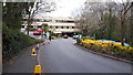
Approach road, Spire Hospital Southampton
Some services have relocated here from University Hospital Southampton during the Coronavirus crisis.
Image: © David Martin
Taken: 2 Apr 2020
0.03 miles
2

Access road, Spire Hospital
Southampton Spire Hospital is a private hospital to the south-east of Southampton General Hospital. This access road is on the far side of a locked gate on Dale Road.
Image: © Jim Champion
Taken: 9 May 2009
0.05 miles
3
Chalybeate Close Southampton
The road leading to the BUPA Chalybeate Hospital recently renamed 'Spire'.
Image: © Val Pollard
Taken: 4 Nov 2007
0.07 miles
4

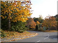
Greenway path approaching Dale Road
This path follows Holly Brook (off to the right) and the green part of the Greenway ends at the upcoming junction with Dale Road and Dale Valley Road.
Image: © Jim Champion
Taken: 4 May 2009
0.07 miles
5
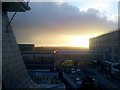
View of the East Wing Annexe from the Old Nurses' Home
View of the Emergency Department and the East Wing Annexe of Southampton General Hospital from the Old Nurses' Home building. The cranes of Southampton Docks can be seen in the distance, with a beautiful winter sunset providing the backdrop.
Image: © Dave Waghorn
Taken: 26 Jan 2012
0.08 miles
6

Dale Road, looking uphill towards the hospital
Image: © David Martin
Taken: 13 Nov 2023
0.09 miles
7

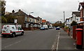
Seacole Gardens
Flats and parking spaces on the south side of Seacole Gardens. The junction with Dale Road is straight ahead.
Image: © Jim Champion
Taken: 29 Apr 2009
0.09 miles
8
St James Park Road, Southampton
St James Park Road is a 150 metre long cul-de-sac, viewed from the Winchester Road end.
Image: © Jaggery
Taken: 16 Nov 2013
0.09 miles

10

Dale Road
From the mini-roundabout junction with Tremona Road, Dale Road descends into the Dale Valley and rises again on the far side.
Image: © Jim Champion
Taken: 29 Apr 2009
0.10 miles