IMAGES TAKEN NEAR TO
Seagarth Lane, SOUTHAMPTON, SO16 6SX
Introduction
This page details the photographs taken nearby to Seagarth Lane, SO16 6SX by members of the Geograph project.
The Geograph project started in 2005 with the aim of publishing, organising and preserving representative images for every square kilometre of Great Britain, Ireland and the Isle of Man.

There are currently over 7.5m images from over14,400 individuals and you can help contribute to the project by visiting https://www.geograph.org.uk
Image Map
Images are licensed for reuse under creativecommons.org/licenses/by-sa/2.0
Notes
- Clicking on the map will re-center to the selected point.
- The higher the marker number, the further away the image location is from the centre of the postcode.
Image Listing (97 Images Found)
Images are licensed for reuse under creativecommons.org/licenses/by-sa/2.0
Image
Details
Distance
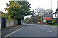
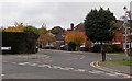
1
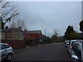
Looking north-northeast up Seagarth Lane
Image: © Basher Eyre
Taken: 4 Dec 2014
0.02 miles
2
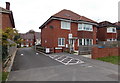
Holly Place, Southampton
Access to recently-built houses in Holly Place is from Winchester Road.
The notice on the lamppost shows 'Keep access road clear at all times. No Parking.'
Image: © Jaggery
Taken: 16 Nov 2013
0.07 miles
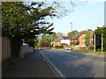
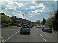
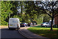
5
A35 Winchester Road, Southampton
Heading west.
Image: © Robin Webster
Taken: 13 Nov 2022
0.09 miles
6
Winchester Road junction with Burgess Road
Image: © Stuart Logan
Taken: 7 May 2012
0.09 miles
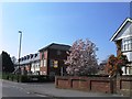
9
Burgess Road, Southampton
Viewed across the A35 Winchester Road. This is the isolated SW part of Burgess road, no longer a through road for motor vehicles. A 1940s map shows that it was part of an A road at that time, without the bend seen here. The straight section of road behind the lamppost was formerly part of the A road.
Image: © Jaggery
Taken: 16 Nov 2013
0.10 miles
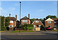
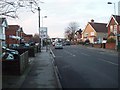
10
Malwood Avenue, Upper Shirley
The southern end of Malwood Avenue from the corner in Seymour Road.
Image: © Jim Champion
Taken: 28 Sep 2008
0.10 miles