IMAGES TAKEN NEAR TO
Lordswood Road, SOUTHAMPTON, SO16 6SA
Introduction
This page details the photographs taken nearby to Lordswood Road, SO16 6SA by members of the Geograph project.
The Geograph project started in 2005 with the aim of publishing, organising and preserving representative images for every square kilometre of Great Britain, Ireland and the Isle of Man.

There are currently over 7.5m images from over14,400 individuals and you can help contribute to the project by visiting https://www.geograph.org.uk
Image Map
Images are licensed for reuse under creativecommons.org/licenses/by-sa/2.0
Notes
- Clicking on the map will re-center to the selected point.
- The higher the marker number, the further away the image location is from the centre of the postcode.
Image Listing (56 Images Found)
Images are licensed for reuse under creativecommons.org/licenses/by-sa/2.0
Image
Details
Distance
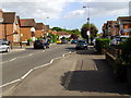
1
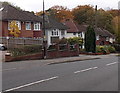
Lordswood Road houses, Southampton
Viewed from near the Hill Lane junction looking towards the Lordswood area of Southampton.
Image: © Jaggery
Taken: 16 Nov 2013
0.03 miles
3
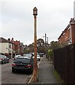
Not a lamppost in Highclere Road, Southampton
This rusty metal post looked at first glance to be a lamppost, but there is no lamp,
and no apparent access point to the grille at the top.
Image: © Jaggery
Taken: 16 Nov 2013
0.06 miles
4
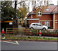
Schoolchildren statues at an entrance to Hollybrook Infant School, Southampton
Viewed across Lordswood Road.
Image: © Jaggery
Taken: 16 Nov 2013
0.07 miles
5
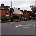
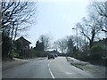
Hill Lane mini-roundabout, Southampton
At the Lordswood Road junction.
Image: © Jaggery
Taken: 16 Nov 2013
0.07 miles
6
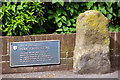
The Hode Cross Stone, Hill Lane
The medieval town boundaries extended well outside the walls. The burgesses controlled an area enclosed by Hill Lane, Burgess Street (now Burgess Road) and the land west of the River Itchen. The limits of the old town were marked by boundary stones, some of which still survive like the Hode Cross Stone seen here on the upper part of Hill Lane. This particular stone marked the north-west point of the ancient boundary of Southampton - its original position on the opposite side of the road is now marked by a stud. Another boundary stone survives nearby on Burgess Road, see Image
Image: © Jim Champion
Taken: 9 May 2009
0.10 miles
7

The bowling green, Southampton Outdoor Sports Centre
Image: © David Martin
Taken: 6 Jun 2010
0.11 miles
8
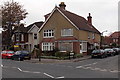
Style-listic hair studio, Southampton
On the corner of Hill Lane and Rockleigh Road.
Image: © Jaggery
Taken: 16 Nov 2013
0.11 miles
10
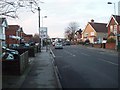
Hill Lane
This is a view along the upper part of Hill Lane (that above the A35 Winchester Road), from the pedestrian crossing towards the Winchester Road roundabout. Rockleigh Road is on the left, and in shadow in the foreground on the right is the displaced Hode Cross Stone.
Image: © Jim Champion
Taken: 8 May 2009
0.12 miles