IMAGES TAKEN NEAR TO
Dale Valley Road, SOUTHAMPTON, SO16 6QN
Introduction
This page details the photographs taken nearby to Dale Valley Road, SO16 6QN by members of the Geograph project.
The Geograph project started in 2005 with the aim of publishing, organising and preserving representative images for every square kilometre of Great Britain, Ireland and the Isle of Man.

There are currently over 7.5m images from over14,400 individuals and you can help contribute to the project by visiting https://www.geograph.org.uk
Image Map
Images are licensed for reuse under creativecommons.org/licenses/by-sa/2.0
Notes
- Clicking on the map will re-center to the selected point.
- The higher the marker number, the further away the image location is from the centre of the postcode.
Image Listing (155 Images Found)
Images are licensed for reuse under creativecommons.org/licenses/by-sa/2.0
Image
Details
Distance
1

Mini-roundabout on Dale Road
Dale Road goes from left-right, with Dale Valley Road straight ahead and the Lordsdale Greenway footpath behind. The Dale Valley Stores is on the left.
Image: © Jim Champion
Taken: 29 Apr 2009
0.03 miles
2
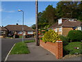
Dale Valley Close
Northern end of Dale Valley Close. Bungalows with hipped roofs.
Image: © Jim Champion
Taken: 29 Apr 2009
0.04 miles

4

Dale Road
From the mini-roundabout junction with Tremona Road, Dale Road descends into the Dale Valley and rises again on the far side.
Image: © Jim Champion
Taken: 29 Apr 2009
0.05 miles
5

Greenway path approaching Dale Road
This path follows Holly Brook (off to the right) and the green part of the Greenway ends at the upcoming junction with Dale Road and Dale Valley Road.
Image: © Jim Champion
Taken: 4 May 2009
0.06 miles
6
Norham Avenue, Upper Shirley
Detached houses on the north side of Norham Avenue, at the end nearest Dale Road.
Image: © Jim Champion
Taken: 28 Sep 2008
0.06 miles
7

Dale Road, looking uphill towards the hospital
Image: © David Martin
Taken: 13 Nov 2023
0.06 miles
8

Dale Valley Road
This is the bend where Dale Valley Road straightens out for a long stretch. Holly Brook runs along behind the semi-detached houses on the right.
Image: © Jim Champion
Taken: 29 Apr 2009
0.06 miles
9
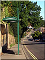
Dale Road, Shirley
Looking down Dale Road towards the mini-roundabout at the junction with Dale Valley Road. Bus stop on the left in the foreground.
Image: © Jim Champion
Taken: 13 Sep 2009
0.06 miles
10
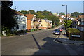
Dale Road, Shirley
View along Dale Road from the western end of Norham Avenue. Buildings at Southampton General Hospital are visible in the distance - ambulances headed for the accident and emergency department are frequently seen (and heard) on this road.
Image: © Jim Champion
Taken: 28 Sep 2008
0.07 miles