IMAGES TAKEN NEAR TO
Leaside Way, SOUTHAMPTON, SO16 3DP
Introduction
This page details the photographs taken nearby to Leaside Way, SO16 3DP by members of the Geograph project.
The Geograph project started in 2005 with the aim of publishing, organising and preserving representative images for every square kilometre of Great Britain, Ireland and the Isle of Man.

There are currently over 7.5m images from over14,400 individuals and you can help contribute to the project by visiting https://www.geograph.org.uk
Image Map
Images are licensed for reuse under creativecommons.org/licenses/by-sa/2.0
Notes
- Clicking on the map will re-center to the selected point.
- The higher the marker number, the further away the image location is from the centre of the postcode.
Image Listing (21 Images Found)
Images are licensed for reuse under creativecommons.org/licenses/by-sa/2.0
Image
Details
Distance
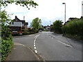
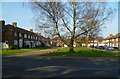
3
Looking north on Stoneham Lane across the junction with Channels Farm Road
Image: © Shazz
Taken: 4 Mar 2013
0.09 miles
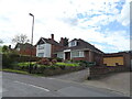
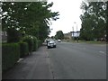
4
Bungalows, Bassett Green Road A27
Seen from the junction with Stoneham Lane.
Image: © Robin Stott
Taken: 31 May 2011
0.09 miles
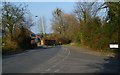
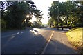
6
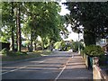
South end of Stoneham Lane
Leafy suburbs are tricky to photograph because the trees hide the houses.
Image: © Robin Stott
Taken: 31 May 2011
0.10 miles
7
79 to 51 Bassett Green Road
Looking across the A27 in Southampton.
Image: © DS Pugh
Taken: 26 Aug 2016
0.11 miles
8
Swaythling, Bassett Green Road
A27, this section from Swaythling to Bassett Green.
Image: © Mike Faherty
Taken: 17 Jul 2010
0.11 miles
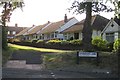
9
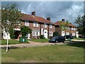
Herbert Collins houses in Bassett Green
Image: © David Martin
Taken: 15 Aug 2011
0.12 miles
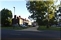
10
Junction with Stoneham Lane
The A27 Bassett Green Road crosses Stoneham Lane.
Image: © DS Pugh
Taken: 26 Aug 2016
0.12 miles