IMAGES TAKEN NEAR TO
Phillimore Road, SOUTHAMPTON, SO16 2NQ
Introduction
This page details the photographs taken nearby to Phillimore Road, SO16 2NQ by members of the Geograph project.
The Geograph project started in 2005 with the aim of publishing, organising and preserving representative images for every square kilometre of Great Britain, Ireland and the Isle of Man.

There are currently over 7.5m images from over14,400 individuals and you can help contribute to the project by visiting https://www.geograph.org.uk
Image Map
Images are licensed for reuse under creativecommons.org/licenses/by-sa/2.0
Notes
- Clicking on the map will re-center to the selected point.
- The higher the marker number, the further away the image location is from the centre of the postcode.
Image Listing (77 Images Found)
Images are licensed for reuse under creativecommons.org/licenses/by-sa/2.0
Image
Details
Distance

2
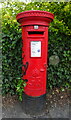
George V postbox on Stoneham Lane, Southampton
Postbox No. SO16 365.
Image: © JThomas
Taken: 25 Apr 2022
0.07 miles
3

Fallen tree outside the shops at Swaythling
Just when you've nearly finished the new block paving...
Image: © David Martin
Taken: 15 Feb 2014
0.07 miles
4
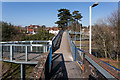
Footbridge from Swaythling railway station
Ahead the footbridge spans Stoneham Way dual carriageway.
Image: © Peter Facey
Taken: 14 Mar 2013
0.07 miles
5
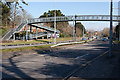
Footbridge over Stoneham Way
Going at right to Swaythling railway station. See also http://www.geograph.org.uk/photo/3373533
Image: © Peter Facey
Taken: 14 Mar 2013
0.07 miles
6
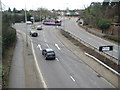
Swaythling: A335 Stoneham Way and A35 Burgess Road junction
The dual carriageway in the foreground is the A335 Stoneham Way. At the junction the A335 peels off to the left into Thomas Lewis Way, while the A35 Burgess Road is straight ahead at the lights. The two marks across the road are trench scars of some underground utility installation, not violent skid marks resulting from someone's late decision that the A335 was preferable to the A35.
Image: © Nigel Cox
Taken: 24 Jan 2010
0.08 miles
7

City Gateway development, under construction at Swaythling (5)
The wrapping is now all removed and the fit-out of the ground floor retail units is well advanced. New paving and planting on the photographer's side of the road make it difficult to locate exactly the same viewpoint as for Image
Image: © David Martin
Taken: 6 May 2014
0.08 miles
8

City Gateway halls of residence, five years on
University of Southampton halls of residence, just over five years after Image
Image: © David Martin
Taken: 8 Aug 2019
0.09 miles
9

City Gateway development, under construction at Swaythling
This new 15-storey tower will provide student residences, with businesses at ground level.
Image: © David Martin
Taken: 8 Jun 2013
0.09 miles
10

Southampton City Gateway under construction
Looking along Stoneham Way at this construction site, with Thomas Lewis Way on the left. The agents for the development are Hughes Ellard http://www.hughesellard.com whose particulars state "a major mixed use development which will provide 364 student accommodation units, let to the University of Southampton, a 6 GP medical centre, a Lloyds Pharmacy and a number of commercial/retail units. At the centre of the scheme will be an open landscaped area with managed car parking. Handover of the commercial units is proposed for summer 2014. Units of between 105 to 470 sq m (1,129 to 5,057 sq ft)". From the aerial view it would appear that the site was formerly commercial with car parking.
The developers are Bouyges Development http://bouygues-development.com whose web site gives the project start date as 1st October 2012, completion 31st July 2014, approximate value £24 million. The architect is Stride Treglown.
Image: © Peter Facey
Taken: 14 Mar 2013
0.09 miles