IMAGES TAKEN NEAR TO
Lincoln Court, SOUTHAMPTON, SO15 7PY
Introduction
This page details the photographs taken nearby to Lincoln Court, SO15 7PY by members of the Geograph project.
The Geograph project started in 2005 with the aim of publishing, organising and preserving representative images for every square kilometre of Great Britain, Ireland and the Isle of Man.

There are currently over 7.5m images from over14,400 individuals and you can help contribute to the project by visiting https://www.geograph.org.uk
Image Map
Images are licensed for reuse under creativecommons.org/licenses/by-sa/2.0
Notes
- Clicking on the map will re-center to the selected point.
- The higher the marker number, the further away the image location is from the centre of the postcode.
Image Listing (81 Images Found)
Images are licensed for reuse under creativecommons.org/licenses/by-sa/2.0
Image
Details
Distance
1
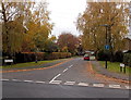
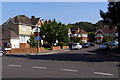
Lincoln Court, Southampton
Viewed across Hill Lane.
Image: © Jaggery
Taken: 16 Nov 2013
0.03 miles
2
Leicester Road, Southampton
Viewed across Hill Lane.
Image: © Jaggery
Taken: 16 Nov 2013
0.05 miles
3
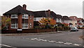
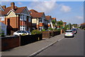
Leicester Road, Upper Shirley
Looking west along Leicester Road from close to the junction with Hill Lane.
Image: © Jim Champion
Taken: 27 Sep 2008
0.05 miles
4
Junction of Leicester Road and Melrose Road
Leicester Road is in the foreground, with Melrose Road leading off to the north. The monkey puzzle tree is a prominent feature at this junction.
Image: © Jim Champion
Taken: 27 Sep 2008
0.07 miles
5
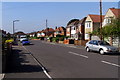
Shanklin Crescent, Shirley
Shanklin Crescent is a cul-de-sac of detached and semi-detached houses with a turning circle at its far end. The junction with Shanklin Road is seen in the foreground.
Image: © Jim Champion
Taken: 27 Sep 2008
0.07 miles
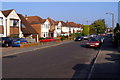
6
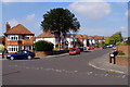
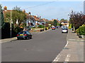
Shanklin Road, Upper Shirley
Looking north-west up the road, these dwellings on the west side of the street are a mixture of similar detached and semi-detached houses.
Image: © Jim Champion
Taken: 27 Sep 2008
0.08 miles
7
Shanklin Road, Upper Shirley
Shanklin Road heads slightly uphill to the junction with Warwick Road. The turning on the right in the foreground is Leicester Road and the left turn a little further up the road is Luccombe Place. The road names in this part of Upper Shirley have a Midlands/Isle of Wight theme.
Image: © Jim Champion
Taken: 27 Sep 2008
0.09 miles
8
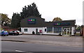
Vets4Pets, Hill Lane, Southampton
Veterinary surgery at 252 Hill Lane, opposite Southampton Common.
Image: © Jaggery
Taken: 16 Nov 2013
0.10 miles
9
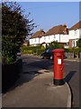
Postbox on the corner of Luccombe Place and Shanklin Road
A Georgian postbox on the corner of Luccombe Place and Shanklin Road. It dates from the development of this suburban estate of detached and semi-detached houses.
Image: © Jim Champion
Taken: 28 Sep 2008
0.10 miles
10
Melrose Road, Upper Shirley
Houses on the west side of the lower part of Melrose Road, close to the junction with Leicester Road.
Image: © Jim Champion
Taken: 28 Sep 2008
0.10 miles