IMAGES TAKEN NEAR TO
Radway Road, SOUTHAMPTON, SO15 7PT
Introduction
This page details the photographs taken nearby to Radway Road, SO15 7PT by members of the Geograph project.
The Geograph project started in 2005 with the aim of publishing, organising and preserving representative images for every square kilometre of Great Britain, Ireland and the Isle of Man.

There are currently over 7.5m images from over14,400 individuals and you can help contribute to the project by visiting https://www.geograph.org.uk
Image Map
Images are licensed for reuse under creativecommons.org/licenses/by-sa/2.0
Notes
- Clicking on the map will re-center to the selected point.
- The higher the marker number, the further away the image location is from the centre of the postcode.
Image Listing (83 Images Found)
Images are licensed for reuse under creativecommons.org/licenses/by-sa/2.0
Image
Details
Distance
1

Radway Crescent, Shirley
Radway Crescent is a cul-de-sac off Radway Road. It backs onto the western side of King Edward VI school.
Image: © Jim Champion
Taken: 13 Apr 2009
0.02 miles
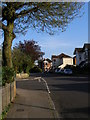
2
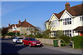
Radway Road, Shirley
These semi-detached houses are on the east side of the lower part of Radway Road. The junction is with Radway Crescent (a cul-de-sac).
Image: © Jim Champion
Taken: 13 Apr 2009
0.03 miles
3

Radway Crescent, Shirley
Radway Crescent is a cul-de-sac off Radway Road. It backs onto the western side of King Edward VI school, part of which can be seen beyond the houses.
Image: © Jim Champion
Taken: 13 Apr 2009
0.03 miles
4
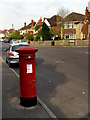
Postbox on Radway Road
A red pillar box on the west side of Radway Road, opposite the junction with Kellett Road.
Image: © Jim Champion
Taken: 14 Apr 2009
0.03 miles
5
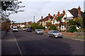
Radway Road, Shirley
Looking across the road towards the detached houses on the east side of Radway Road, north of the junction with Kellett Road.
Image: © Jim Champion
Taken: 14 Apr 2009
0.06 miles
6
Kellett Road, Southampton
Viewed from Hill Lane at the edge of Southampton Common.
Image: © Jaggery
Taken: 16 Nov 2013
0.06 miles
7
Junction of Wilton Road and Radway Road
The turning to the left off Wilton Road is Radway Road.
Image: © Jim Champion
Taken: 13 Apr 2009
0.06 miles
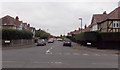
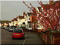
8

Kellett Road, Shirley
View east along Kellett Road towards its junction with Hill Lane. The '20 is plenty' sign on the left is present because there is a school entrance (King Edward VI School) on the right.
Image: © Jim Champion
Taken: 13 Apr 2009
0.06 miles
9
Wilton Crescent, Shirley
Semi-detached houses on the east side of Wilton Crescent, lit by late afternoon spring sunshine.
Image: © Jim Champion
Taken: 12 Apr 2009
0.06 miles
10
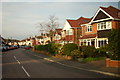
Wilton Crescent, Shirley
Houses on the east side of the lower part of Wilton Crescent, just north of the wide junction with Wilton Road. After these few detached houses it is semi-detached all the way up to Wilton Gardens.
Image: © Jim Champion
Taken: 12 Apr 2009
0.07 miles