IMAGES TAKEN NEAR TO
Crown Street, SOUTHAMPTON, SO15 5LJ
Introduction
This page details the photographs taken nearby to Crown Street, SO15 5LJ by members of the Geograph project.
The Geograph project started in 2005 with the aim of publishing, organising and preserving representative images for every square kilometre of Great Britain, Ireland and the Isle of Man.

There are currently over 7.5m images from over14,400 individuals and you can help contribute to the project by visiting https://www.geograph.org.uk
Image Map
Images are licensed for reuse under creativecommons.org/licenses/by-sa/2.0
Notes
- Clicking on the map will re-center to the selected point.
- The higher the marker number, the further away the image location is from the centre of the postcode.
Image Listing (130 Images Found)
Images are licensed for reuse under creativecommons.org/licenses/by-sa/2.0
Image
Details
Distance
1
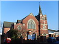
Shirley Baptist Church, Southampton
Situated in Church Street off the A3057 Shirley Road, this red-brick Church would seem to date from the 19th Century. Its postcode is SO15 5LG.
Image: © David Hillas
Taken: 17 Feb 2010
0.02 miles
2
Shirley Baptist Church, Church Street, Shirley
Image: © David Martin
Taken: 27 May 2010
0.02 miles
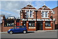
4
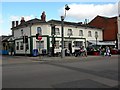
The Crown, Shirley High Street
Perhaps unsurprisingly, this is on the corner of Crown Street
Image: © Keith Edkins
Taken: 16 Feb 2010
0.02 miles
5
The Crown
Public house on Shirley High Street.
Image: © dennis huteson
Taken: 7 Oct 2006
0.03 miles
6
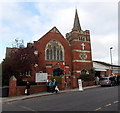
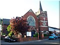
Shirley Baptist Church, Southampton
Viewed across Church Street from near the corner of Shirley High Street.
The church opened for worship in 1915, replacing the original church built in 1852.
Image: © Jaggery
Taken: 16 Nov 2013
0.03 miles
7
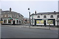
Bank and betting shop in Shirley
The betting shop was quite possibly once a pub. The building behind is part of Sainsbury's.
Image: © Bill Boaden
Taken: 28 Sep 2016
0.03 miles
8
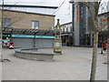
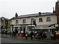
Shirley precinct, Shirley
Showing feature horse trough.
Image: © Alex McGregor
Taken: 12 Mar 2010
0.04 miles
10
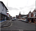
Church Street, Shirley, Southampton
Viewed from the corner of Vincent Street looking towards Shirley High Street.
The Kings Arms pub http://www.geograph.org.uk/photo/3777122 is on the right.
The church spire is part of Shirley Baptist Church. http://www.geograph.org.uk/photo/3777052
Image: © Jaggery
Taken: 16 Nov 2013
0.04 miles