IMAGES TAKEN NEAR TO
Bramston Road, SOUTHAMPTON, SO15 5GH
Introduction
This page details the photographs taken nearby to Bramston Road, SO15 5GH by members of the Geograph project.
The Geograph project started in 2005 with the aim of publishing, organising and preserving representative images for every square kilometre of Great Britain, Ireland and the Isle of Man.

There are currently over 7.5m images from over14,400 individuals and you can help contribute to the project by visiting https://www.geograph.org.uk
Image Map
Images are licensed for reuse under creativecommons.org/licenses/by-sa/2.0
Notes
- Clicking on the map will re-center to the selected point.
- The higher the marker number, the further away the image location is from the centre of the postcode.
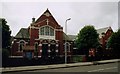
Image Listing (66 Images Found)
Images are licensed for reuse under creativecommons.org/licenses/by-sa/2.0
Image
Details
Distance
1
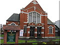
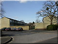
St. James Road Methodist Church, Southampton
Image: © Alex McGregor
Taken: 31 Mar 2010
0.04 miles
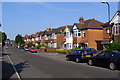
3
Shirley Avenue
View down Shirley Avenue towards Shirley Road, from the junction with St James Road. It truly is an avenue, lined with a variety of different tree species including silver birch and horse chestnut.
Image: © Jim Champion
Taken: 21 Sep 2008
0.09 miles
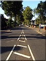
4
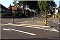
Busy junction, St James Road
The island and road markings in the foreground are part of the junction 'complex' where St James Road is met by Twyford Avenue, Upper Shirley Avenue and Shirley Avenue (straight ahead). Presumably this was once a wide open 'free for all' when the suburb was new and cars were a rare.
Image: © Jim Champion
Taken: 21 Sep 2008
0.10 miles
5
Shirley, Howard's Grove
Housing in one of the several turns off Howard's Grove. Note mistletoe in the tree to the right; a common feature locally.
Image: © Mike Faherty
Taken: 2 Mar 2010
0.11 miles
6
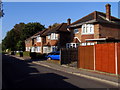
Detached houses, Howard's Grove
These houses are at the north-east end of Howard's Grove, close to the junction with St James Road.
Image: © Jim Champion
Taken: 21 Sep 2008
0.12 miles
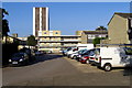
7
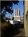
Path west from Howard's Grove
This path leads west from Howard's Grove, between the residents' car park on the left and the terrace-ends on the right. In the distance is Shirley Towers.
Image: © Jim Champion
Taken: 21 Sep 2008
0.14 miles
8
St James Road from Howard's Grove
A view north-west along St James Road from the end of Howard's Grove. The paved front garden with low brick wall and roses is a classic of a certain era of 20th century suburban design. Someone has whited-out the ard' from the streetsign in the foreground. The apostrophe has been banished from the modern St James Road signs (sometimes St James's Road, sometimes St James' Road) and it is simply "St James Road" on the official Post Office/local council lists.
Image: © Jim Champion
Taken: 21 Sep 2008
0.14 miles
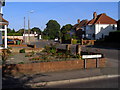
9
Darlington Gardens, Shirley
View along the semi-detached houses of the western part of Darlington Gardens. The houses on the right back onto the houses of Bridlington Avenue. The crossroads junction with Wilton Road is further on down the street.
Image: © Jim Champion
Taken: 11 May 2009
0.15 miles
10
Residents' car park off Howard's Grove
Looking west from Howard's Grove, this is a car parking area for residents of the nearby houses. The estate of terraced houses and flats is laid out in alignment with the N-S/E-W of the Ordnance Survey grid.
Image: © Jim Champion
Taken: 21 Sep 2008
0.15 miles