IMAGES TAKEN NEAR TO
Charlton Road, SOUTHAMPTON, SO15 5EX
Introduction
This page details the photographs taken nearby to Charlton Road, SO15 5EX by members of the Geograph project.
The Geograph project started in 2005 with the aim of publishing, organising and preserving representative images for every square kilometre of Great Britain, Ireland and the Isle of Man.

There are currently over 7.5m images from over14,400 individuals and you can help contribute to the project by visiting https://www.geograph.org.uk
Image Map
Images are licensed for reuse under creativecommons.org/licenses/by-sa/2.0
Notes
- Clicking on the map will re-center to the selected point.
- The higher the marker number, the further away the image location is from the centre of the postcode.
Image Listing (60 Images Found)
Images are licensed for reuse under creativecommons.org/licenses/by-sa/2.0
Image
Details
Distance
1
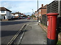
An autumnal anti-clockwise stroll (38)
Postbox in Charlton Road
Image: © Basher Eyre
Taken: 30 Oct 2012
0.04 miles
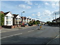
2
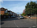
An autumnal anti-clockwise stroll (37)
Looking from Malmesbury Road into Norfolk Road.
Image: © Basher Eyre
Taken: 30 Oct 2012
0.05 miles
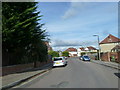
4
An autumnal anti-clockwise stroll (36)
Junction of Raymond and Malmesbury Roads, as seen from end of St James Road.
Image: © Basher Eyre
Taken: 30 Oct 2012
0.09 miles
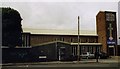
6
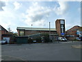
An autumnal anti-clockwise stroll (35)
St John's Centre in St James Road
Image: © Basher Eyre
Taken: 30 Oct 2012
0.10 miles
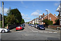
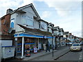
9
An autumnal anti-clockwise stroll (39)
Mid section of Charlton Road
Image: © Basher Eyre
Taken: 30 Oct 2012
0.12 miles