IMAGES TAKEN NEAR TO
Paynes Road, SOUTHAMPTON, SO15 3SH
Introduction
This page details the photographs taken nearby to Paynes Road, SO15 3SH by members of the Geograph project.
The Geograph project started in 2005 with the aim of publishing, organising and preserving representative images for every square kilometre of Great Britain, Ireland and the Isle of Man.

There are currently over 7.5m images from over14,400 individuals and you can help contribute to the project by visiting https://www.geograph.org.uk
Image Map
Images are licensed for reuse under creativecommons.org/licenses/by-sa/2.0
Notes
- Clicking on the map will re-center to the selected point.
- The higher the marker number, the further away the image location is from the centre of the postcode.
Image Listing (104 Images Found)
Images are licensed for reuse under creativecommons.org/licenses/by-sa/2.0
Image
Details
Distance
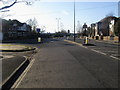
1
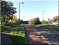
Bus lane and cycle lane on the road to Millbrook railway station, Southampton
The reddish road surface indicates the combined bus lane and cycle lane.
Image: © Jaggery
Taken: 16 Nov 2013
0.04 miles
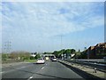
3
Paynes Road, Freemantle
Having to split so that it can link with the A33 just ahead.
Image: © Bill Boaden
Taken: 28 Sep 2016
0.04 miles
4
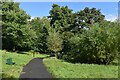
Path in Freemantle Lake Park
Former grounds of a house which included a lake, now filled in.
Image: © David Martin
Taken: 6 Aug 2023
0.05 miles
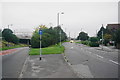
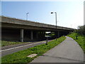
5
Payne's Road
Payne's Road passing Waterloo Road heading out under Mountbatten Way
Image: © Shaun Ferguson
Taken: 30 Jan 2010
0.07 miles
7
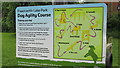
Information board Freemantle Lake Park Dog Agility Course
The free dog agility course provided by Southampton City Council in January 2012 at Freemantle Lake Park. There are proposal to build a secure fully fenced dog park now at Central Parks in some disused tennis courts http://www.southampton.gov.uk/people-places/parks-open-spaces/central/improvements.aspx
Image: © J W Parker
Taken: 1 Jun 2015
0.08 miles
8
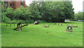
Dog agility course in Freemantle Lake Park installed in January 2012
Dog agility course in Freemantle Lake Park installed in January 2012. The whole park is quite securely fenced but not specifically the agility area, there is also an enclosed dog area in Portswood Rec. There are also proposals to turn some disused tennis courts in central parks into a Dog Park http://www.southampton.gov.uk/policies/2-lawn%20courts.pdf If you would like to express your views to the council about enclosed Dog Parks please email them at [email protected]
Image: © J W Parker
Taken: 1 Jun 2015
0.08 miles
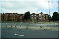
10
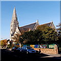
Christ Church Southampton
Viewed across Waterloo Road. Christ Church is on the corner of Paynes Road in the Freemantle district of Southampton.
Image: © Jaggery
Taken: 16 Nov 2013
0.09 miles