IMAGES TAKEN NEAR TO
Bourne Road, SOUTHAMPTON, SO15 3SA
Introduction
This page details the photographs taken nearby to Bourne Road, SO15 3SA by members of the Geograph project.
The Geograph project started in 2005 with the aim of publishing, organising and preserving representative images for every square kilometre of Great Britain, Ireland and the Isle of Man.

There are currently over 7.5m images from over14,400 individuals and you can help contribute to the project by visiting https://www.geograph.org.uk
Image Map
Images are licensed for reuse under creativecommons.org/licenses/by-sa/2.0
Notes
- Clicking on the map will re-center to the selected point.
- The higher the marker number, the further away the image location is from the centre of the postcode.
Image Listing (383 Images Found)
Images are licensed for reuse under creativecommons.org/licenses/by-sa/2.0
Image
Details
Distance
1
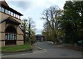
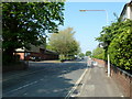
An autumnal anti-clockwise stroll (61)
Looking from Millbrook Road into Bourne Road.
Image: © Basher Eyre
Taken: 30 Oct 2012
0.01 miles
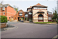
2
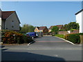
Looking from Bourne Road through to Edith Haisman Close
Image: © Basher Eyre
Taken: 20 Apr 2011
0.01 miles

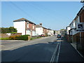
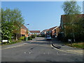
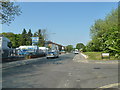
7
Bourne Road
With Millbrook Road East in foreground.
Image: © Peter Facey
Taken: 26 Jan 2010
0.02 miles
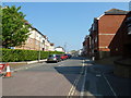
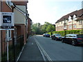
8
Looking from Millbrook Road East into Edith Haisman Close
Image: © Basher Eyre
Taken: 20 Apr 2011
0.02 miles
10
Junction of Millbrook Road East and Edith Haisman Close
Image: © Basher Eyre
Taken: 20 Apr 2011
0.03 miles