IMAGES TAKEN NEAR TO
Shirley Road, SOUTHAMPTON, SO15 3HL
Introduction
This page details the photographs taken nearby to Shirley Road, SO15 3HL by members of the Geograph project.
The Geograph project started in 2005 with the aim of publishing, organising and preserving representative images for every square kilometre of Great Britain, Ireland and the Isle of Man.

There are currently over 7.5m images from over14,400 individuals and you can help contribute to the project by visiting https://www.geograph.org.uk
Image Map
Images are licensed for reuse under creativecommons.org/licenses/by-sa/2.0
Notes
- Clicking on the map will re-center to the selected point.
- The higher the marker number, the further away the image location is from the centre of the postcode.
Image Listing (115 Images Found)
Images are licensed for reuse under creativecommons.org/licenses/by-sa/2.0
Image
Details
Distance
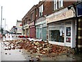
1
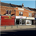
Sanjha, Southampton
Punjabi Indian restaurant and takeaway at 296 Shirley Road, on the corner of Harold Road.
Image: © Jaggery
Taken: 16 Nov 2013
0.01 miles
2
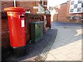
Postbox at the corner of Grove Road
Image: © Christine Johnstone
Taken: 17 Feb 2010
0.01 miles
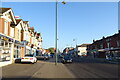
5
Corner of Lumsden Avenue and Shirley Road, Southampton
Shirley Road is on the left.
Image: © Jaggery
Taken: 16 Nov 2013
0.02 miles
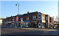
7
Portobello Pizza, Southampton
Portobello Pizza on the left is at 301 Shirley Road. Also in view are Gasworks and Dainty Tailors.
Image: © Jaggery
Taken: 16 Nov 2013
0.03 miles
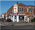
8
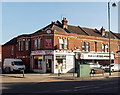
Sleep Tight, Shirley, Southampton
Bed shop on the corner of Shirley Road and Newlands Avenue.
Image: © Jaggery
Taken: 16 Nov 2013
0.03 miles