IMAGES TAKEN NEAR TO
Wolseley Road, SOUTHAMPTON, SO15 3ES
Introduction
This page details the photographs taken nearby to Wolseley Road, SO15 3ES by members of the Geograph project.
The Geograph project started in 2005 with the aim of publishing, organising and preserving representative images for every square kilometre of Great Britain, Ireland and the Isle of Man.

There are currently over 7.5m images from over14,400 individuals and you can help contribute to the project by visiting https://www.geograph.org.uk
Image Map
Images are licensed for reuse under creativecommons.org/licenses/by-sa/2.0
Notes
- Clicking on the map will re-center to the selected point.
- The higher the marker number, the further away the image location is from the centre of the postcode.
Image Listing (81 Images Found)
Images are licensed for reuse under creativecommons.org/licenses/by-sa/2.0
Image
Details
Distance

2
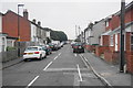
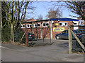
Wolseley Road, Shirley
A fairly unremarkable residential road in the suburbs.
Image: © Bill Boaden
Taken: 28 Sep 2016
0.06 miles
3
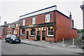
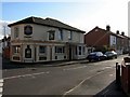
The Freemantle Arms, Freemantle
Another excellent pub on back streets, which you would not find if you didn't know it was here. It is not to be confused with the nearby Freemantle.
Freemantle appears to have more than its fair share of good pubs compared with other Southampton suburbs.
Image: © Bill Boaden
Taken: 28 Sep 2016
0.06 miles
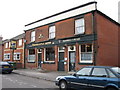
4
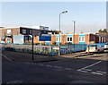
This used to be the 'Duchess of Wellington'
The 'Duchess of Wellington' has been sold and converted into living accommodation. See imageImage
Image: © Mark
Taken: 29 Feb 2012
0.07 miles
6
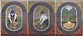
Ceramic murals at Strawberry Fields, Shirley
These three panels are on the gable ends of the housing terraces at Strawberry Fields in Shirley. The ceramic panels, by John Hodgson, were commissioned by Southampton City to commemorate the market-gardening history of the people of Shirley. Shirley did not become part of Southampton until the 1890s. There was little industry in the area and Shirley still had farms, allotments and nurseries. Fields of vegetables and soft fruits, including strawberries, were grown for local markets. After 1918 many of the fields were sold for housing as Shirley continued to expand, eventually forming one of the city's largest western suburbs.
Image: © Jim Champion
Taken: 25 Feb 2006
0.07 miles
7

Strawberry Fields, Shirley, Southampton
These houses, and several nearby terraces, are collectively known as "Strawberry Fields". The plaque on the wall (underneath the satellite dish) explains that the ceramic panels on these buildings were commissioned by Southampton City to commemorate the market-gardening history of the people of Shirley. Shirley did not become part of Southampton until the 1890s. There was little industry in the area and Shirley still had farms, allotments and nurseries. Fields of vegetables and soft fruits, including strawberries, were grown for local markets. After 1918 many of the fields were sold for housing as Shirley continued to expand, eventually forming one of the city's largest western suburbs.
Image: © Jim Champion
Taken: 25 Feb 2006
0.07 miles
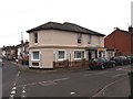
8
The Duchess of Wellington
Pub in Freemantle on the corner of Firgrove Road and Woolesley Road.
Image: © dennis huteson
Taken: 7 Oct 2006
0.08 miles
9
Shirley Health Centre, Southampton
On the corner of Randolph Street and Grove Road.
Image: © Jaggery
Taken: 16 Nov 2013
0.08 miles
10
Shirley Swimming Pool, Kentish Road
Shirley Swimming Pool is a privately owned, public swimming pool. Built in 1974 as a dedicated teaching centre, the two pool site offers lessons for every age and ability, starting from 6 months. The main 25 metre pool is available for general swimming and adult lane swimming, whilst the small pool is available for public swimming between lessons. Info from here: http://www.shirleyswimmingpool.co.uk/
Image: © Jim Champion
Taken: 25 Feb 2006
0.09 miles