IMAGES TAKEN NEAR TO
Queenstown Road, SOUTHAMPTON, SO15 3BG
Introduction
This page details the photographs taken nearby to Queenstown Road, SO15 3BG by members of the Geograph project.
The Geograph project started in 2005 with the aim of publishing, organising and preserving representative images for every square kilometre of Great Britain, Ireland and the Isle of Man.

There are currently over 7.5m images from over14,400 individuals and you can help contribute to the project by visiting https://www.geograph.org.uk
Image Map
Images are licensed for reuse under creativecommons.org/licenses/by-sa/2.0
Notes
- Clicking on the map will re-center to the selected point.
- The higher the marker number, the further away the image location is from the centre of the postcode.
Image Listing (209 Images Found)
Images are licensed for reuse under creativecommons.org/licenses/by-sa/2.0
Image
Details
Distance
1
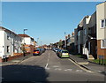
Queenstown Road Southampton
Viewed across Waterloo Road in the Freemantle area of Southampton.
Image: © Jaggery
Taken: 16 Nov 2013
0.02 miles

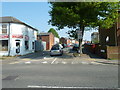
3
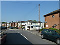
Approaching the crossroads of Queenstown Road and Mansion Road
Image: © Basher Eyre
Taken: 20 Apr 2011
0.03 miles
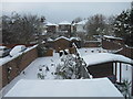
4

Looking from Waterloo Road into Queenstown Road
Image: © Basher Eyre
Taken: 20 Apr 2011
0.03 miles
6
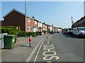
Curiously stationary pupils outside Freemantle Academy
Image: © Basher Eyre
Taken: 20 Apr 2011
0.05 miles
8
Looking from Waterloo Road into Mansion Road
Image: © Basher Eyre
Taken: 20 Apr 2011
0.05 miles
9

Junction of Waterloo and Queenstown Roads
Image: © Basher Eyre
Taken: 20 Apr 2011
0.05 miles
