IMAGES TAKEN NEAR TO
Lakelands Drive, SOUTHAMPTON, SO15 3AL
Introduction
This page details the photographs taken nearby to Lakelands Drive, SO15 3AL by members of the Geograph project.
The Geograph project started in 2005 with the aim of publishing, organising and preserving representative images for every square kilometre of Great Britain, Ireland and the Isle of Man.

There are currently over 7.5m images from over14,400 individuals and you can help contribute to the project by visiting https://www.geograph.org.uk
Image Map
Images are licensed for reuse under creativecommons.org/licenses/by-sa/2.0
Notes
- Clicking on the map will re-center to the selected point.
- The higher the marker number, the further away the image location is from the centre of the postcode.
Image Listing (97 Images Found)
Images are licensed for reuse under creativecommons.org/licenses/by-sa/2.0
Image
Details
Distance
1
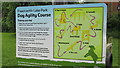
Information board Freemantle Lake Park Dog Agility Course
The free dog agility course provided by Southampton City Council in January 2012 at Freemantle Lake Park. There are proposal to build a secure fully fenced dog park now at Central Parks in some disused tennis courts http://www.southampton.gov.uk/people-places/parks-open-spaces/central/improvements.aspx
Image: © J W Parker
Taken: 1 Jun 2015
0.03 miles
2
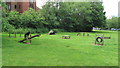
Dog agility course in Freemantle Lake Park installed in January 2012
Dog agility course in Freemantle Lake Park installed in January 2012. The whole park is quite securely fenced but not specifically the agility area, there is also an enclosed dog area in Portswood Rec. There are also proposals to turn some disused tennis courts in central parks into a Dog Park http://www.southampton.gov.uk/policies/2-lawn%20courts.pdf If you would like to express your views to the council about enclosed Dog Parks please email them at [email protected]
Image: © J W Parker
Taken: 1 Jun 2015
0.03 miles

4

Houses in Foundry Lane seen from Millbrook station footbridge
Image: © David Martin
Taken: 30 Oct 2016
0.04 miles
5

Smoke from docks fire over Millbrook Station
Image: © Alex McGregor
Taken: 17 Apr 2012
0.05 miles
6

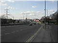
Bus shelter beside the A33, for Millbrook Station
The railway station is on the other side of the dual carriageway and is accessed via a footbridge to the right of this photograph. Note the e-scooter stand, a more recent addition.
Image: © David Martin
Taken: 6 Aug 2023
0.06 miles
8
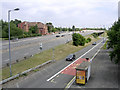
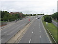
Freemantle junction of the A33 dual carriageway, Southampton
View southeast from the footbridge over the dual carriageway to Millbrook station. The A33 carries traffic from Totton/M271 to Southampton city centre.
Image: © Jim Champion
Taken: 9 Jul 2005
0.08 miles
9
Freemantle, footbridge
Footbridge over busy Millbrook Road West (A33), with the entrance to Millbrook Station to the left.
Image: © Mike Faherty
Taken: 2 Mar 2010
0.08 miles