IMAGES TAKEN NEAR TO
College Place, SOUTHAMPTON, SO15 2XL
Introduction
This page details the photographs taken nearby to College Place, SO15 2XL by members of the Geograph project.
The Geograph project started in 2005 with the aim of publishing, organising and preserving representative images for every square kilometre of Great Britain, Ireland and the Isle of Man.

There are currently over 7.5m images from over14,400 individuals and you can help contribute to the project by visiting https://www.geograph.org.uk
Image Map
Images are licensed for reuse under creativecommons.org/licenses/by-sa/2.0
Notes
- Clicking on the map will re-center to the selected point.
- The higher the marker number, the further away the image location is from the centre of the postcode.
Image Listing (236 Images Found)
Images are licensed for reuse under creativecommons.org/licenses/by-sa/2.0
Image
Details
Distance
1
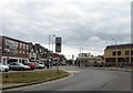
View along London Road
The tower of the civic centre is visible in the far distance.
Image: © Fernweh
Taken: 16 Jul 2014
0.02 miles
3
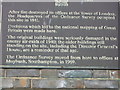
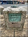
Ordnance Survey, London Road site, 1841-1969
Plaque detailing Ordnance Survey history
Image: © Alex McGregor
Taken: 3 Apr 2010
0.02 miles
4
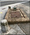
Old Ordnance Survey Headquarters - London Road - Southampton (a)
The old Ordnancee Survey headquarters on London Road in Southampton
There is a Fundamental Benchmsrk (FBM) located just outside this building. The plaque on the wall states that the site was occupied by the OS from 1841 to 1969
See links below for related photos
Image]
Image]
Image]
Image]
Image: © Tez Exley
Taken: 26 Jun 2023
0.04 miles
5
Fundamental Bench Mark - London Road - Southampton (a)
A Fundamental benchmark outside the old Ordnance Survey building on London Road in Southampton which moved in 1969
See links to related photos below:
Image]
Image]
Image]
Image]
Image: © Tez Exley
Taken: 26 Jun 2023
0.04 miles
6
Fundamental Bench Mark - London Road - Southampton (b)
A Fundamental benchmark outside the old Ordnance Survey building on London Road in Southampton. The offices moved to a new site in 1969
See links to related photos below:
Image]
Image]
Image]
Image]
Image: © Tez Exley
Taken: 26 Jun 2023
0.04 miles
7
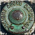
Fundamental Bench Mark - London Road - Southampton (c)
A Fundamental benchmark outside the old Ordnance Survey building on London Road in Southampton. The offices moved to a new site in 1969
See links to related photos below:
Image]
Image]
Image]
Image]
Image: © Tez Exley
Taken: 26 Jun 2023
0.04 miles
8
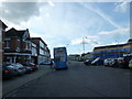
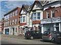
An autumnal anti-clockwise stroll (9)
University bus in College Place
Image: © Basher Eyre
Taken: 30 Oct 2012
0.04 miles
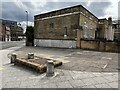
9
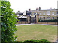
Court Buildings
Grand brick buildings which look like they were of former military origin.
Image: © Colin Smith
Taken: 12 May 2007
0.04 miles
10
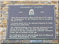
Ordnance Survey Plaque, Barrack House, Southampton.
Sited on London Road, facing across to Ordnance Road, is this 1841- former home of the OS HQ.
Image: © Colin Smith
Taken: 25 Nov 2007
0.04 miles