IMAGES TAKEN NEAR TO
Millbrook Road East, SOUTHAMPTON, SO15 1HS
Introduction
This page details the photographs taken nearby to Millbrook Road East, SO15 1HS by members of the Geograph project.
The Geograph project started in 2005 with the aim of publishing, organising and preserving representative images for every square kilometre of Great Britain, Ireland and the Isle of Man.

There are currently over 7.5m images from over14,400 individuals and you can help contribute to the project by visiting https://www.geograph.org.uk
Image Map
Images are licensed for reuse under creativecommons.org/licenses/by-sa/2.0
Notes
- Clicking on the map will re-center to the selected point.
- The higher the marker number, the further away the image location is from the centre of the postcode.
Image Listing (104 Images Found)
Images are licensed for reuse under creativecommons.org/licenses/by-sa/2.0
Image
Details
Distance
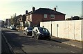
1
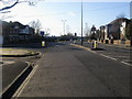
Payne's Road
Payne's Road passing Waterloo Road heading out under Mountbatten Way
Image: © Shaun Ferguson
Taken: 30 Jan 2010
0.03 miles
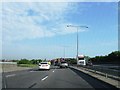
2
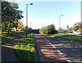
Bus lane and cycle lane on the road to Millbrook railway station, Southampton
The reddish road surface indicates the combined bus lane and cycle lane.
Image: © Jaggery
Taken: 16 Nov 2013
0.03 miles
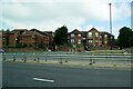
3
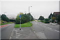
Paynes Road, Freemantle
Having to split so that it can link with the A33 just ahead.
Image: © Bill Boaden
Taken: 28 Sep 2016
0.03 miles
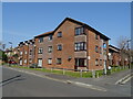
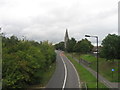
5
Almond Road Southampton
Viewed from the Waterloo Road end looking towards Millbrook Road East.
Image: © Jaggery
Taken: 16 Nov 2013
0.05 miles
9
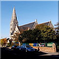
Christ Church Southampton
Viewed across Waterloo Road. Christ Church is on the corner of Paynes Road in the Freemantle district of Southampton.
Image: © Jaggery
Taken: 16 Nov 2013
0.08 miles
10
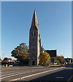
Tower of Christ Church, Southampton
Paynes Road is on the left side of the church, Waterloo Road on the right.
Image: © Jaggery
Taken: 16 Nov 2013
0.08 miles