IMAGES TAKEN NEAR TO
Old Redbridge Road, SOUTHAMPTON, SO15 0NJ
Introduction
This page details the photographs taken nearby to Old Redbridge Road, SO15 0NJ by members of the Geograph project.
The Geograph project started in 2005 with the aim of publishing, organising and preserving representative images for every square kilometre of Great Britain, Ireland and the Isle of Man.

There are currently over 7.5m images from over14,400 individuals and you can help contribute to the project by visiting https://www.geograph.org.uk
Image Map
Images are licensed for reuse under creativecommons.org/licenses/by-sa/2.0
Notes
- Clicking on the map will re-center to the selected point.
- The higher the marker number, the further away the image location is from the centre of the postcode.
Image Listing (91 Images Found)
Images are licensed for reuse under creativecommons.org/licenses/by-sa/2.0
Image
Details
Distance
1
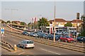
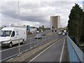
Nissan Garage south of Redbridge Flyover
Looking across the dual carriageway of the flyover, which is an area prohibited to pedestrians. The traffic in the far lane is held up by the traffic lights.
Image: © Peter Facey
Taken: 28 Sep 2008
0.03 miles
2
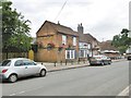
Redbridge, Ship Inn
Historic public house on Old Redbridge Road, listed by Historic England as C16 or C17, and ascribed by the management to 1564. Internally, back bar, with drinking and eating areas left, front and right; open fireplaces, wooden beams, stone flags and exposed brickwork. The pub has outside seating, a garden, background music and games machines. Cask ales on offer at my visit: Ringwood Forty Niner & Razor Back, Sharp's Doom Bar. The building is listed, Grade II: http://www.imagesofengland.org.uk/Details/Default.aspx?id=135865&mode=adv
Image: © Mike Faherty
Taken: 1 Jul 2017
0.03 miles
3
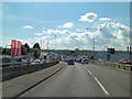
Atop the Redbridge Flyover
The A35 crosses over the roundabout the allows access to the M271. Here the view is towards the bridge that carries traffic over the Redbridge Channel towards the western shore of the Solent.
Image: © Stuart Logan
Taken: 7 May 2012
0.04 miles
4
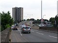
Eastbound view of Redbridge flyover and Redbridge Towers
Image: © David Martin
Taken: 20 May 2008
0.04 miles
5
Redbridge Flyover from Redbridge Causeway
Looking towards the Redbridge Flyover and Redbridge Towers from the cycle-way across Redbridge Causeway. Beneath the flyover is a roundabout that marks the Southampton end of the M271 motorway. The blue tower of the DAF building on the left has a display on either side that alternately shows the time and air temperature. Curiously the temperature on one of the displays is always 2 degrees higher than the other.
Image: © Jim Champion
Taken: 21 Feb 2007
0.04 miles
6
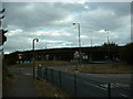
Redbridge Roundabout, Southampton
The Redbridge Roundabout and flyover, Southampton
Image: © GaryReggae
Taken: 19 Jul 2005
0.06 miles
7
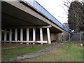
Beneath Redbridge Causeway
Looking from Old Redbridge Road beneath the eastern ramp of Redbridge Causeway (which carries the A35 dual carriageway across the River Test). Redbridge Towers is poking up to the left of the tree.
Image: © Jim Champion
Taken: 21 Feb 2007
0.06 miles
8
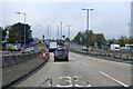
A35 descending from Redbridge Flyover
Heading west, approaching the bridges over a railway and the River Test.
Image: © Robin Webster
Taken: 13 Nov 2022
0.07 miles
9
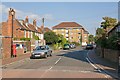
Old Redbridge Road
The square blocks of flats, of which there are seven, are named Clover Nook. The one in view is numbers 81 to 96.
Image: © Peter Facey
Taken: 28 Sep 2008
0.07 miles
10
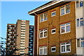
Redbridge Towers and Clover Nooke
Redbridge Towers is the tall block on the left, across the other side of the A35.
Image: © David Martin
Taken: 19 Nov 2017
0.07 miles