IMAGES TAKEN NEAR TO
Avenue Road, SOUTHAMPTON, SO14 6TR
Introduction
This page details the photographs taken nearby to Avenue Road, SO14 6TR by members of the Geograph project.
The Geograph project started in 2005 with the aim of publishing, organising and preserving representative images for every square kilometre of Great Britain, Ireland and the Isle of Man.

There are currently over 7.5m images from over14,400 individuals and you can help contribute to the project by visiting https://www.geograph.org.uk
Image Map
Images are licensed for reuse under creativecommons.org/licenses/by-sa/2.0
Notes
- Clicking on the map will re-center to the selected point.
- The higher the marker number, the further away the image location is from the centre of the postcode.
Image Listing (65 Images Found)
Images are licensed for reuse under creativecommons.org/licenses/by-sa/2.0
Image
Details
Distance
1
Alma Road, Southampton
Viewed from The Avenue
Image: © Alex McGregor
Taken: 3 Apr 2010
0.05 miles
2
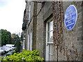
Jellicoe's Birthplace
A round blue plaque marks the house where John Jellicoe, first Earl Jellicoe, Admiral of the Fleet during World War 1, was born.
Image: © Colin Smith
Taken: 12 May 2007
0.06 miles
3
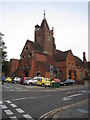
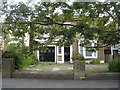
Buildings along The Avenue
All overlooking a busy access road but once were probably a great place to live close to Southampton Common.
Image: © Mr Ignavy
Taken: 19 Sep 2010
0.07 miles
4
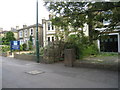
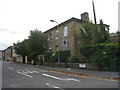
Once a fine town house
The Avenue, Portswood.
Image: © Mr Ignavy
Taken: 19 Sep 2010
0.07 miles
5

Off-licence, Cambridge Road, Southampton
Specialising in beer
Image: © Alex McGregor
Taken: 3 Apr 2010
0.07 miles
6
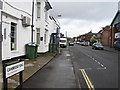
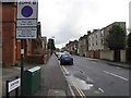
Cambridge Road, Southampton
Viewed from Lodge Road
Image: © Alex McGregor
Taken: 3 Apr 2010
0.07 miles
8
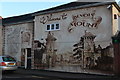
"Welcome to Bevois Mount" mural, Alma Road
Image: © David Martin
Taken: 29 Oct 2017
0.08 miles
9
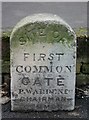
Old Commemorative Marker by the A33, The Avenue, Southampton
Commemorative Marker by the A33, in parish of Southampton (Southampton District), The Avenue, outside No. 48, at junction with Avenue Road and opposite the similar HA_WISObcm. HER number MSH4339 https://www.heritagegateway.org.uk/Gateway/Results_Single.aspx?uid=MSH4339&resourceID=1016.
Inscription reads:- : SITE OF / FIRST / COMMON / GATE / P.WARDEN.Esq / CHAIRMAN / COMMON :
Surveyed
Milestone Society National ID: HA_WISO10acm.
Image: © K Lawrence
Taken: 6 Feb 2005
0.08 miles