IMAGES TAKEN NEAR TO
Liverpool Street, SOUTHAMPTON, SO14 6FZ
Introduction
This page details the photographs taken nearby to Liverpool Street, SO14 6FZ by members of the Geograph project.
The Geograph project started in 2005 with the aim of publishing, organising and preserving representative images for every square kilometre of Great Britain, Ireland and the Isle of Man.

There are currently over 7.5m images from over14,400 individuals and you can help contribute to the project by visiting https://www.geograph.org.uk
Image Map
Images are licensed for reuse under creativecommons.org/licenses/by-sa/2.0
Notes
- Clicking on the map will re-center to the selected point.
- The higher the marker number, the further away the image location is from the centre of the postcode.
Image Listing (138 Images Found)
Images are licensed for reuse under creativecommons.org/licenses/by-sa/2.0
Image
Details
Distance
1
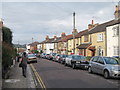
Middle Street, Southampton
Viewed from The Avenue
Image: © Alex McGregor
Taken: 3 Apr 2010
0.02 miles
2
Southcliff Road, Southampton
Pedestrianised section
Image: © Alex McGregor
Taken: 3 Apr 2010
0.05 miles
3
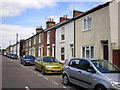
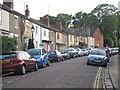
Victorian housing, Methuen Street, Southampton
Traditional Victorian terraced housing in Methuen Street, behind the Inner Avenue.
Image: © GaryReggae
Taken: 21 Jul 2008
0.06 miles
6
Rockstone Lane
Note the American highway patrol car, promotional car for the Rockstone pub at the start of the dead end residential road.
Image: © Oast House Archive
Taken: 29 Jun 2012
0.09 miles
8
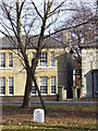
Milestone on The Avenue
Stone marker on the main road north from Southampton, leading to Winchester and London. The Avenue here has a wide grassy centre and has become a stretch of dual carriageway. Here it is lined by grand, substantial detached stone buildings.
Image: © Colin Smith
Taken: 25 Nov 2007
0.11 miles
9
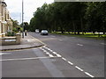
The Avenue heading into the city centre
The Avenue passing Padwell Road heading into the city centre
Image: © Shaun Ferguson
Taken: 16 Aug 2008
0.11 miles
10
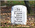
Milestone in Southampton
Sited on west carriageway of The Avenue, this milestone carries the archaic spelling for Winchester - whose inhabitants are called Wintonians. Southampton has been reduced to Southton - which is longer than the term Soton sometimes used today.
Image: © Colin Smith
Taken: 25 Nov 2007
0.11 miles