IMAGES TAKEN NEAR TO
Crosshouse Road, SOUTHAMPTON, SO14 5GZ
Introduction
This page details the photographs taken nearby to Crosshouse Road, SO14 5GZ by members of the Geograph project.
The Geograph project started in 2005 with the aim of publishing, organising and preserving representative images for every square kilometre of Great Britain, Ireland and the Isle of Man.

There are currently over 7.5m images from over14,400 individuals and you can help contribute to the project by visiting https://www.geograph.org.uk
Image Map
Images are licensed for reuse under creativecommons.org/licenses/by-sa/2.0
Notes
- Clicking on the map will re-center to the selected point.
- The higher the marker number, the further away the image location is from the centre of the postcode.
Image Listing (125 Images Found)
Images are licensed for reuse under creativecommons.org/licenses/by-sa/2.0
Image
Details
Distance
1
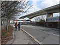
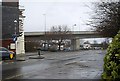
Crosshouse Road, Southampton.
Viewed from Endle Street with Itchen Bridge looming over.
Image: © Alex McGregor
Taken: 21 Mar 2010
0.01 miles
2
Crosshouse Road, Southampton
The road is a cul de sac that ends with a hard running into the River Itchen.
I think the Cross House is the little building with the domed tiled roof. Its stonework is in a cross shape, however it is engraved 1988 whereas Southampton City Council lists the Cross House as a monument. What is a "cross house"? Does it refer to the shape of the house, or does it mark a river crossing point?
Image: © Peter Facey
Taken: 26 May 2007
0.02 miles
3

Business units off Crosshouse Road, Southampton
Called Cross House Centre.
Image: © Robin Webster
Taken: 2 Oct 2016
0.03 miles
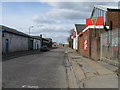
4

Small businesses, Southampton
On Crosshouse Road and Endle Street.
Image: © Robin Webster
Taken: 2 Oct 2016
0.04 miles
5
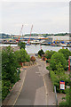
View From the Itchen Bridge, Southampton (2)
Photograph taken from the north side of the Itchen Bridge. This is an ideal vantage point from which to study the city, river, and industry. The River Itchen joins Southampton Water to the east of the city, and about 0.75 mile (1.2 kilometre) down stream of this location.
Looking across part of the industrial estate; beyond, is the River Itchen.
Image: © Peter Trimming
Taken: 2 Mar 2010
0.04 miles
6
Endle Street, Southampton
Looking NW with the entrance to the recycling amenity on the right.
Image: © Alex McGregor
Taken: 21 Mar 2010
0.05 miles
7
Western end of Itchen Bridge
From edge of Ocean Village.
Image: © Stanley Howe
Taken: 18 Feb 2010
0.05 miles
8

Itchen shore, Southampton
There is a hard here, the boat on the trailer seems to have been taken out of the water using it.
Image: © Robin Webster
Taken: 2 Oct 2016
0.06 miles
9
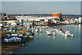
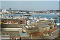
View From the Itchen Bridge, Southampton (4)
Photograph taken from the north side of the Itchen Bridge. This is an ideal vantage point from which to study the city, river, and industry. The River Itchen joins Southampton Water to the east of the city, and about 0.75 mile (1.2 kilometre) down stream of this location.
A variety of cruisers are moored up at this location, looking somewhat out of place next to the nearby industry.
Image: © Peter Trimming
Taken: 2 Mar 2010
0.07 miles
10
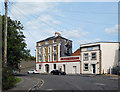
The Royal Albert Hotel
Closed and converted to apartments.
Image: © Des Blenkinsopp
Taken: 23 Aug 2018
0.07 miles