IMAGES TAKEN NEAR TO
Nelson Street, SOUTHAMPTON, SO14 5GQ
Introduction
This page details the photographs taken nearby to Nelson Street, SO14 5GQ by members of the Geograph project.
The Geograph project started in 2005 with the aim of publishing, organising and preserving representative images for every square kilometre of Great Britain, Ireland and the Isle of Man.

There are currently over 7.5m images from over14,400 individuals and you can help contribute to the project by visiting https://www.geograph.org.uk
Image Map
Images are licensed for reuse under creativecommons.org/licenses/by-sa/2.0
Notes
- Clicking on the map will re-center to the selected point.
- The higher the marker number, the further away the image location is from the centre of the postcode.
Image Listing (174 Images Found)
Images are licensed for reuse under creativecommons.org/licenses/by-sa/2.0
Image
Details
Distance
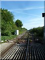
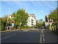
1
View south from Chapel Road crossing, Southampton
The single track line goes to the eastern docks.
Image: © Gareth James
Taken: 18 Feb 2011
0.02 miles
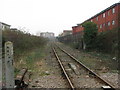
2
Railway towards Southampton Docks
From the level crossing on Chapel Road.
Image: © JThomas
Taken: 27 Apr 2022
0.03 miles
5
View along Chapel Road from level crossing
Image: © Roger Templeman
Taken: 5 May 2012
0.04 miles
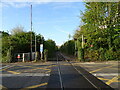
6
Chapel Road level crossing, Southampton
The ungated crossing is for the line to the eastern docks.
Image: © Gareth James
Taken: 18 Feb 2011
0.04 miles
7
Junction of Chapel and Granville Streets
Image: © Basher Eyre
Taken: 24 Jun 2011
0.05 miles
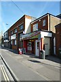
9
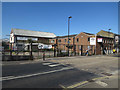
John Cribb & Sons electrical wholesalers
As was, seemingly closed down.
Image: © Hugh Venables
Taken: 2 Jul 2018
0.05 miles