IMAGES TAKEN NEAR TO
Anglesea Terrace, SOUTHAMPTON, SO14 5BL
Introduction
This page details the photographs taken nearby to Anglesea Terrace, SO14 5BL by members of the Geograph project.
The Geograph project started in 2005 with the aim of publishing, organising and preserving representative images for every square kilometre of Great Britain, Ireland and the Isle of Man.

There are currently over 7.5m images from over14,400 individuals and you can help contribute to the project by visiting https://www.geograph.org.uk
Image Map
Images are licensed for reuse under creativecommons.org/licenses/by-sa/2.0
Notes
- Clicking on the map will re-center to the selected point.
- The higher the marker number, the further away the image location is from the centre of the postcode.
Image Listing (152 Images Found)
Images are licensed for reuse under creativecommons.org/licenses/by-sa/2.0
Image
Details
Distance
1
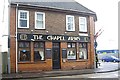
The Chapel Arms pub
On the corner of Anglesea Terrace and Albert Road North. A watering hole for 'Saints' fans - Southampton FC ground is just up the road.
Image: © Stanley Howe
Taken: 18 Feb 2010
0.02 miles
2
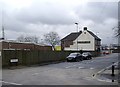
Anglesea Terrace, Chapel
With 'The Chapel Arms' on the far corner.
Image: © Stanley Howe
Taken: 18 Feb 2010
0.02 miles
3
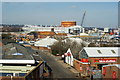
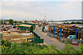
View From the Itchen Bridge, Southampton (1)
Photograph taken from the north side of the Itchen Bridge. This is an ideal vantage point from which to study the city, river, and industry. The River Itchen joins Southampton Water to the east of the city, and about 0.75 mile (1.2 kilometre) down stream of this location.
Looking over part of the industrial estate, in the direction of St.Mary's Stadium (home of Southampton Football club).
Image: © Peter Trimming
Taken: 2 Mar 2010
0.06 miles
4
Travis Perkins, Southampton
Building supplies.
Image: © Robin Webster
Taken: 2 Oct 2016
0.07 miles
5
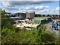
Ryde Terrace, Southampton
Seen from flank of Itchen Bridge. Travis Perkins builders merchant on left.
Image: © Peter Facey
Taken: 26 May 2007
0.07 miles
6
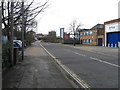
Crosshouse Road, Southampton.
Viewed from Endle Street.
Image: © Alex McGregor
Taken: 21 Mar 2010
0.07 miles
7
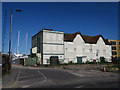
American Wharf
Long-disused building on Marine Parade, see Image
Image: © Hugh Venables
Taken: 2 Jul 2018
0.09 miles
8
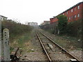
View south from Chapel Road crossing, Southampton
The single track line goes to the eastern docks.
Image: © Gareth James
Taken: 18 Feb 2011
0.09 miles
9
Junction of Chapel and Granville Streets
Image: © Basher Eyre
Taken: 24 Jun 2011
0.09 miles
10

American Wharf building
On Albert Road North. Currently disused, but open to offers.
Image: © Stanley Howe
Taken: 18 Feb 2010
0.09 miles