IMAGES TAKEN NEAR TO
Queens Terrace, SOUTHAMPTON, SO14 3SG
Introduction
This page details the photographs taken nearby to Queens Terrace, SO14 3SG by members of the Geograph project.
The Geograph project started in 2005 with the aim of publishing, organising and preserving representative images for every square kilometre of Great Britain, Ireland and the Isle of Man.

There are currently over 7.5m images from over14,400 individuals and you can help contribute to the project by visiting https://www.geograph.org.uk
Image Map
Images are licensed for reuse under creativecommons.org/licenses/by-sa/2.0
Notes
- Clicking on the map will re-center to the selected point.
- The higher the marker number, the further away the image location is from the centre of the postcode.
Image Listing (473 Images Found)
Images are licensed for reuse under creativecommons.org/licenses/by-sa/2.0
Image
Details
Distance
2

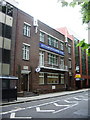
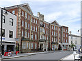
Southampton Seafarers Centre, Queen's Terrace, Southampton
An inscription below the ground floor central window reads: The Missions to Seamen / To the glory of God / and for the welfare of all / who serve on the seven seas / this stone was laid on Nov.12th. 1935 by / the Rt. Hon. the Earl of Athlone K.G. / President.
The view is from Queen's Park. Other views: Image and Image
Image: © Robin Stott
Taken: 26 Jun 2014
0.01 miles
3
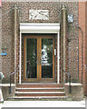
Entrance to Southampton Seafarers Centre, Queen's Terrace, Southampton
Image: © Robin Stott
Taken: 26 Jun 2014
0.01 miles
4

Southampton Seafarers Centre, Queen's Terrace, Southampton
An inscription below the ground floor central window reads: The Missions to Seamen / To the glory of God / and for the welfare of all / who serve on the seven seas / this stone was laid on Nov.12th. 1935 by / the Rt. Hon. the Earl of Athlone K.G. / President.
The entrance on the right is seen in Image
Image: © Robin Stott
Taken: 26 Jun 2014
0.01 miles
6
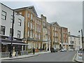
The Booth Centre ? Salvation Army hostel for sailors, 57 Oxford Street, Southampton
The inscription in relief at roof level above the entrance reads: SAILORS' HOME.
Image: © Robin Stott
Taken: 25 Jun 2014
0.02 miles
7
The Booth Centre
Built in 1909 as Mountbatten House, it was originally a Seamen's Home, as indicated by the inscription in the pediment. The top storey was added in 1912 and the west part added in 1930. It became a Salvation Army men's hostel in 1970, but in 2008 it was completely rebuilt as a general centre for the homeless, and only the facade is original.
Image: © Alan Murray-Rust
Taken: 28 Jun 2014
0.02 miles
8
Southampton, Sailors' Home
On Oxford Street; according to the plaque, a sailors' home from 1909-69. Now a Salvation Army hostel. http://www.dailyecho.co.uk/heritage/titanic/trail/locations/9443582.Sailors__Home/
Image: © Mike Faherty
Taken: 26 Nov 2016
0.02 miles
9
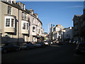
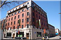
The bend of Oxford Street, Southampton, looking southeast
The bowed oriel windows, left, are a feature seen also in nearby Queen's Terrace: Image and Image The building in shadow on the right is the Booth Centre, a Salvation Army hostel Image The congenial eastern end of Oxford Street is all places to eat and drink: http://www.geograph.org.uk/search.php?i=59931351&page=1
Image: © Robin Stott
Taken: 25 Jun 2014
0.03 miles
10
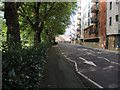
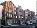
Queen's Terrace, Southampton
Part of a loop by Dock Gate 4.
Image: © Hugh Venables
Taken: 22 Jul 2012
0.03 miles