IMAGES TAKEN NEAR TO
Lower Canal Walk, SOUTHAMPTON, SO14 3JQ
Introduction
This page details the photographs taken nearby to Lower Canal Walk, SO14 3JQ by members of the Geograph project.
The Geograph project started in 2005 with the aim of publishing, organising and preserving representative images for every square kilometre of Great Britain, Ireland and the Isle of Man.

There are currently over 7.5m images from over14,400 individuals and you can help contribute to the project by visiting https://www.geograph.org.uk
Image Map
Images are licensed for reuse under creativecommons.org/licenses/by-sa/2.0
Notes
- Clicking on the map will re-center to the selected point.
- The higher the marker number, the further away the image location is from the centre of the postcode.
Image Listing (976 Images Found)
Images are licensed for reuse under creativecommons.org/licenses/by-sa/2.0
Image
Details
Distance
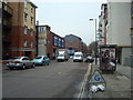
1
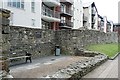
Friary Reredorter
Part of the Friary on the eastern side of the town but within the walls. It has had a variety of uses, as seen here Image Now it is overlooked by much more modern flats.
Image: © Graham Horn
Taken: 28 Jul 2009
0.01 miles
2
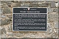
Friary Reredorter
An information board at the Friary Reredorter, seen here Image]
Image: © Graham Horn
Taken: 28 Jul 2009
0.01 miles
3
Friary Gate, Southampton Town Walls
Built in 1373 for Franciscan Friars. See Image for an earlier view.
Image: © Hugh Venables
Taken: 28 Apr 2022
0.02 miles
4
Friary Gate
The eastern gate through the town walls, built in 1373 to allow the Friars access to the poor suburb of Newton outside the walls where they had orchards and gardens. Information from one of the notice boards.
Image: © Graham Horn
Taken: 28 Jul 2009
0.02 miles
6
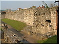
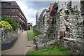
Friary Gate - Southampton City Wall
The placard reads - This small postern gate was built in 1373/74 by the friars to give access to their gardens lying outside the town wall. A square two-storey tower, it added to the town defences and carried two guns in the time of war. The gateway and its associated bridge across the town ditch went out or use in the late sixteenth century.
Image: © Malcolm Grant
Taken: 5 Apr 2002
0.02 miles
7
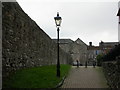
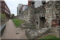
Southampton, city walls
An impressively preserved section of the walls, as seen from the Round Tower in the street appropriately called "Back of the Walls". In the background, God's House Tower, now the city's archaeological museum. See item 67G at http://www.southampton.gov.uk/Images/Scheduled%20Monuments%20in%20Southampton_tcm46-161791.pdf
Image: © Mike Faherty
Taken: 11 Dec 2009
0.03 miles
8
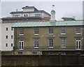
Bowling Green House
Business premises of Wainwright Bros & Co Ltd, shipping agents fd 1889. See http://www.wainwrightbros.com/
Image: © Stanley Howe
Taken: 18 Feb 2010
0.03 miles
10
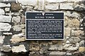
Round Tower
The information board about the Round Tower seen here Image]
Image: © Graham Horn
Taken: 28 Jul 2009
0.03 miles