IMAGES TAKEN NEAR TO
Rudd Way, SOUTHAMPTON, SO14 3GA
Introduction
This page details the photographs taken nearby to Rudd Way, SO14 3GA by members of the Geograph project.
The Geograph project started in 2005 with the aim of publishing, organising and preserving representative images for every square kilometre of Great Britain, Ireland and the Isle of Man.

There are currently over 7.5m images from over14,400 individuals and you can help contribute to the project by visiting https://www.geograph.org.uk
Image Map
Images are licensed for reuse under creativecommons.org/licenses/by-sa/2.0
Notes
- Clicking on the map will re-center to the selected point.
- The higher the marker number, the further away the image location is from the centre of the postcode.
Image Listing (202 Images Found)
Images are licensed for reuse under creativecommons.org/licenses/by-sa/2.0
Image
Details
Distance
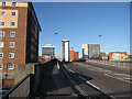
1
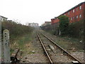
View south from Chapel Road crossing, Southampton
The single track line goes to the eastern docks.
Image: © Gareth James
Taken: 18 Feb 2011
0.07 miles
2
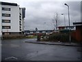
North end of Central Road
In the Chapel area of Southampton.
Image: © Stanley Howe
Taken: 18 Feb 2010
0.08 miles
3
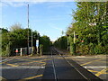
Railway towards Southampton Docks
From the level crossing on Chapel Road.
Image: © JThomas
Taken: 27 Apr 2022
0.09 miles
4
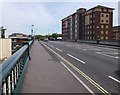
Southampton, Central Bridge
Taking A3025 over Image; the bridge is dated 1882, and has a fine iron balustrade.
Image: © Mike Faherty
Taken: 11 Aug 2012
0.09 miles
5
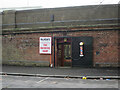
Blades Hairdressing, Terminus Terrace
Image: © Hugh Venables
Taken: 16 Jan 2018
0.10 miles
6
Looking from Chapel Road towards The Compass
Image: © Basher Eyre
Taken: 24 Jun 2011
0.10 miles
7
Central Bridge, Southampton
Over the railway line to the docks.
Image: © Hugh Venables
Taken: 1 Jan 2010
0.11 miles
9
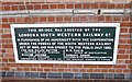
Old Bridge Marker by the A3025, Central Bridge, Southampton
Bridge Marker by the A3025, in parish of Southampton (Southampton District), Central Bridge, against South parapet, East end, high above Royal Crescent Road.
Central Bridge is Grade II listed.
List Entry Number: 1390789 https://historicengland.org.uk/listing/the-list/list-entry/1390789
Surveyed
Milestone Society National ID: HA_SOUT01br
Image: © Milestone Society
Taken: Unknown
0.11 miles
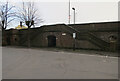
10
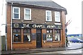
The Chapel Arms pub
On the corner of Anglesea Terrace and Albert Road North. A watering hole for 'Saints' fans - Southampton FC ground is just up the road.
Image: © Stanley Howe
Taken: 18 Feb 2010
0.11 miles