IMAGES TAKEN NEAR TO
Neptune Way, SOUTHAMPTON, SO14 3FN
Introduction
This page details the photographs taken nearby to Neptune Way, SO14 3FN by members of the Geograph project.
The Geograph project started in 2005 with the aim of publishing, organising and preserving representative images for every square kilometre of Great Britain, Ireland and the Isle of Man.

There are currently over 7.5m images from over14,400 individuals and you can help contribute to the project by visiting https://www.geograph.org.uk
Image Map
Images are licensed for reuse under creativecommons.org/licenses/by-sa/2.0
Notes
- Clicking on the map will re-center to the selected point.
- The higher the marker number, the further away the image location is from the centre of the postcode.
Image Listing (262 Images Found)
Images are licensed for reuse under creativecommons.org/licenses/by-sa/2.0
Image
Details
Distance
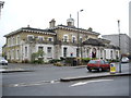
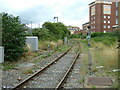
1
The Solent Way (157)
Here Platform Road crosses the single rail line to the docks. Another view is at http://www.geograph.org.uk/photo/1722429
Image: © Shazz
Taken: 31 Aug 2012
0.01 miles
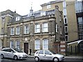
2
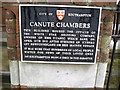
Canute Chambers plaque
A lachrymose spot nearly a century ago.
Image: © Stanley Howe
Taken: 18 Feb 2010
0.02 miles
3
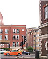
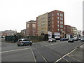
Junction between Canute Road and Neptune Way, Southampton
Image: © nick macneill
Taken: 12 Nov 2010
0.02 miles
6
Canute Road level crossing
A branch line by-passing the old terminus station, and heading (right) to the dockside.
Image: © Stanley Howe
Taken: 18 Feb 2010
0.03 miles
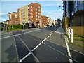
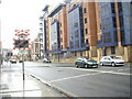
7
Level Crossing at Southampton
Located on Canute Road. View towards the Southampton (city centre) and London direction. The railway line crosses Canute Road, to pass into Southampton Docks. Just out of picture, to the left, was the former London & South Western Railway station; Southampton Terminus. The station closed in 1966, but I remember using it in 1965 or 1966.
Image: © Peter Trimming
Taken: 2 Mar 2010
0.03 miles
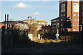
8
Docks branch line
The branch to the eastern side Southampton docks from the main line between St Denys and Southampton Central seen from the level crossing in Canute Road looking towards Central Bridge.
Image: © Rob Candlish
Taken: 3 Aug 2010
0.03 miles
9
Canute Road level crossing, Southampton
Image: © Gareth James
Taken: 18 Feb 2011
0.03 miles
10
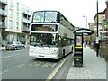
Bus in Canute Road, Southampton
First Group 32036 (W806EOW), an Alexander bodied Volvo B7TL, departing from the westbound bus stop in Canute Road and heading for Lordshill on route 8.
Image: © Rob Candlish
Taken: 3 Aug 2010
0.04 miles