IMAGES TAKEN NEAR TO
SO14 3EQ
Introduction
This page details the photographs taken nearby to SO14 3EQ by members of the Geograph project.
The Geograph project started in 2005 with the aim of publishing, organising and preserving representative images for every square kilometre of Great Britain, Ireland and the Isle of Man.

There are currently over 7.5m images from over14,400 individuals and you can help contribute to the project by visiting https://www.geograph.org.uk
Image Map
Images are licensed for reuse under creativecommons.org/licenses/by-sa/2.0
Notes
- Clicking on the map will re-center to the selected point.
- The higher the marker number, the further away the image location is from the centre of the postcode.
Image Listing (369 Images Found)
Images are licensed for reuse under creativecommons.org/licenses/by-sa/2.0
Image
Details
Distance
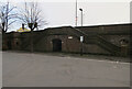
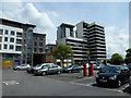
3
Car Park off Threefield Lane
In central Southampton, with offices and flats behind.
Image: © Hugh Venables
Taken: 14 May 2010
0.05 miles
4
Car park between College Street and Bernard Street
Image: © Basher Eyre
Taken: 29 May 2013
0.05 miles
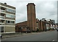
5
Greek Orthodox of St Nicholas, Southampton
Image: © Alexander P Kapp
Taken: 10 Jul 2007
0.06 miles
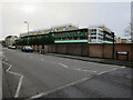
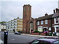
6
Greek Orthodox church in Bernard Street
For more details see http://www.st-nicholas-south.co.uk/
Image: © Basher Eyre
Taken: 29 May 2013
0.06 miles
7
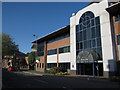
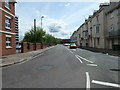
Threefield House
Offices on Threefield Lane on a northwards one-way section. Marsh Lane takes the A33 southwards to the docks and Itchen Bridge.
Image: © Hugh Venables
Taken: 14 May 2010
0.06 miles
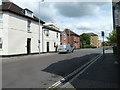
8
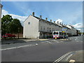
Looking east south-east along Bernard Street
Image: © Basher Eyre
Taken: 29 May 2013
0.07 miles
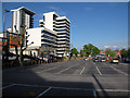
9
Looking from Bernard Street over to Latimer Street
Image: © Basher Eyre
Taken: 29 May 2013
0.07 miles