IMAGES TAKEN NEAR TO
Winkle Street, SOUTHAMPTON, SO14 3AW
Introduction
This page details the photographs taken nearby to Winkle Street, SO14 3AW by members of the Geograph project.
The Geograph project started in 2005 with the aim of publishing, organising and preserving representative images for every square kilometre of Great Britain, Ireland and the Isle of Man.

There are currently over 7.5m images from over14,400 individuals and you can help contribute to the project by visiting https://www.geograph.org.uk
Image Map
Images are licensed for reuse under creativecommons.org/licenses/by-sa/2.0
Notes
- Clicking on the map will re-center to the selected point.
- The higher the marker number, the further away the image location is from the centre of the postcode.
Image Listing (935 Images Found)
Images are licensed for reuse under creativecommons.org/licenses/by-sa/2.0
Image
Details
Distance
1
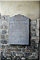
Entrance plaque to St. Julien's church
St. Julien's church, known as the French church, was built in 1196, although much of it is a Victorian rebuild. The French reference is not to the original Norman habitation of Southampton, for this was firmly in the English quarter, but to a later period in history. During the reign of Elizabeth 1st French political refugees (Protestant Walloons and Huguenots) came over to Southampton and the Queen gave them permission to use this church. Some services are still held in French. The interior of the church can be seen here Image
Image: © Graham Horn
Taken: 31 Oct 2009
0.01 miles
2
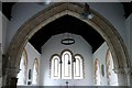
St. Julien's church
St. Julien's church, known as the French church, was built in 1196, although much of it is a Victorian rebuild. The French reference is not to the original Norman habitation of Southampton, for this was firmly in the English quarter, but to a later period in history. During the reign of Elizabeth 1st French political refugees (Protestant Walloons and Huguenots) came over to Southampton and the Queen gave them permission to use this church. Some services are still held in French.
Image: © Graham Horn
Taken: 31 Oct 2009
0.01 miles
3
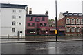
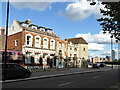
Platform Tavern and other buildings
The Platform Tavern was formerly the home of the Dancing Man Brewery, and still operates as an outlet for its beers.
Image: © Bill Boaden
Taken: 29 Sep 2016
0.01 miles


7
Buildings on Town Quay, Southampton
On the corner is God's House Gate, grade I listed, next Tower House, the lowest building, grade II. The rest are not nationally listed.
Image: © Robin Webster
Taken: 2 Oct 2016
0.01 miles
8
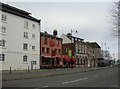
Southampton, Platform Tavern
2010 Good Beer Guide-listed pub on Town Quay. Internally, the city walls form the lefthand boundary, and can be seen; to the left, drinking area, to the right, eating. Cask ales on offer at my visit: Hidden Quest, Pleasure, Fuller's London Pride. For some customer comments, see http://www.beerintheevening.com/pubs/s/18/18322/Platform_Tavern/Southampton
Image: © Mike Faherty
Taken: 11 Dec 2009
0.02 miles
9
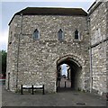
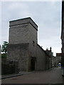
God's House Gate
One of the sea-facing gates in the town wall of Southampton, God's House Gate is named after the hospital (later jail) in the corner of the town wall (the building to the right). A set of sluice gates was integrated into the building, which would allow to operate a tidal water mill.
Image: © Rudi Winter
Taken: 28 Jun 2014
0.02 miles
10

The Platform Tavern, Southampton
Still advertising an 'All summer cider festival' in October.
Image: © Robin Webster
Taken: 2 Oct 2016
0.02 miles