IMAGES TAKEN NEAR TO
Lower Canal Walk, SOUTHAMPTON, SO14 3AN
Introduction
This page details the photographs taken nearby to Lower Canal Walk, SO14 3AN by members of the Geograph project.
The Geograph project started in 2005 with the aim of publishing, organising and preserving representative images for every square kilometre of Great Britain, Ireland and the Isle of Man.

There are currently over 7.5m images from over14,400 individuals and you can help contribute to the project by visiting https://www.geograph.org.uk
Image Map
Images are licensed for reuse under creativecommons.org/licenses/by-sa/2.0
Notes
- Clicking on the map will re-center to the selected point.
- The higher the marker number, the further away the image location is from the centre of the postcode.
Image Listing (917 Images Found)
Images are licensed for reuse under creativecommons.org/licenses/by-sa/2.0
Image
Details
Distance
1
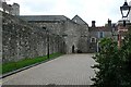
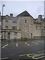
Town walls
Inside the South-eastern section of the town walls.
Image: © Graham Horn
Taken: 28 Jul 2009
0.01 miles
2
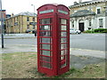
K6 telephone kiosk, Platform Road
A K6 telephone kiosk, designed by Giles Gilbert Scott, opposite Union Castle House, Platform Road, Southampton. Over 60,000 of this design once existed throughout the country. Their numbers are seriously diminished today though.
Image: © Rob Candlish
Taken: 3 Aug 2010
0.01 miles
3
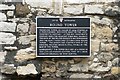
Round Tower
The information board about the Round Tower seen here Image]
Image: © Graham Horn
Taken: 28 Jul 2009
0.01 miles
4
Southampton, clubhouse
On Town Quay, for Southampton Old Bowling Green; according to the sign, the world's oldest bowling green, dating from at least 1299, but not visible because of the wall. https://www.hugofox.com/community/southampton-old-bowling-green-10590/about-us
Image: © Mike Faherty
Taken: 26 Nov 2016
0.01 miles
6
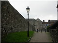
Southampton, city walls
An impressively preserved section of the walls, as seen from the Round Tower in the street appropriately called "Back of the Walls". In the background, God's House Tower, now the city's archaeological museum. See item 67G at http://www.southampton.gov.uk/Images/Scheduled%20Monuments%20in%20Southampton_tcm46-161791.pdf
Image: © Mike Faherty
Taken: 11 Dec 2009
0.02 miles
7
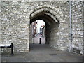
Archway, Gods House Tower
Through the archway the building on the right is St Julien's Church
Image: © Alexander P Kapp
Taken: 10 Jul 2007
0.02 miles
8
Southampton (Old) Bowling Green
Club House off Platform Road.
Image: © Stanley Howe
Taken: 18 Feb 2010
0.02 miles
9

The Solent Way passes God's House Tower
Built in the early 15th. century, the Tower was designed for use with artillery to protect the sluice gate which controlled the flow of water into the town moat.
Image: © Peter Holmes
Taken: 8 Jul 2012
0.02 miles
10
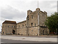
God's House Tower
A plaque fixed to the wall (Image]) gives this information:
"God's House Tower with spur work was built in the early 15th century to protect the sluice gates which controlled the flow of water into the town moat.
The tower is a three-storeyed building with a stone turret stairway leading from the second floor to the battlements. The building was designed for use with artillery and was the headquarters of the town gunner, an important official in the 15th century.
during the 18th century the debtors prison and felons gaol were housed in this ancient fortification"
Image: © David Dixon
Taken: 6 Jul 2016
0.02 miles