IMAGES TAKEN NEAR TO
Town Quay, SOUTHAMPTON, SO14 2ET
Introduction
This page details the photographs taken nearby to Town Quay, SO14 2ET by members of the Geograph project.
The Geograph project started in 2005 with the aim of publishing, organising and preserving representative images for every square kilometre of Great Britain, Ireland and the Isle of Man.

There are currently over 7.5m images from over14,400 individuals and you can help contribute to the project by visiting https://www.geograph.org.uk
Image Map
Images are licensed for reuse under creativecommons.org/licenses/by-sa/2.0
Notes
- Clicking on the map will re-center to the selected point.
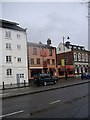
- The higher the marker number, the further away the image location is from the centre of the postcode.
Image Listing (685 Images Found)
Images are licensed for reuse under creativecommons.org/licenses/by-sa/2.0
Image
Details
Distance
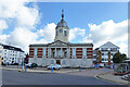
2
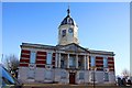
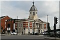
Harbour House, 1 Town Quay
Now housing Maxims Casino.
Image: © Stanley Howe
Taken: 18 Feb 2010
0.03 miles
3
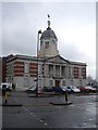
Town Quay (east bay)
The dome on the left is Harbour House.
Image: © Stanley Howe
Taken: 18 Feb 2010
0.03 miles
6
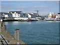
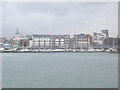
Town Quay, Southampton
Here is where the Red Funnel Fast Jet boats arrive/depart for the Isle of Wight. The Hythe Ferry also uses this terminal.
Image: © Gillian Thomas
Taken: 4 Apr 2007
0.03 miles
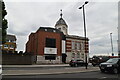
8
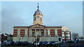
Playhouse Gentlemen's Club, Southampton
A strip club. The former Harbour Board offices, grade II listed, about 1910.
Image: © Robin Webster
Taken: 2 Oct 2016
0.03 miles
10
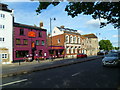
The Solent Way (155)
The walk passes an interestingly purple pub in Southampton.
Image: © Shazz
Taken: 31 Aug 2012
0.03 miles