IMAGES TAKEN NEAR TO
Cook Street, SOUTHAMPTON, SO14 1NJ
Introduction
This page details the photographs taken nearby to Cook Street, SO14 1NJ by members of the Geograph project.
The Geograph project started in 2005 with the aim of publishing, organising and preserving representative images for every square kilometre of Great Britain, Ireland and the Isle of Man.

There are currently over 7.5m images from over14,400 individuals and you can help contribute to the project by visiting https://www.geograph.org.uk
Image Map
Images are licensed for reuse under creativecommons.org/licenses/by-sa/2.0
Notes
- Clicking on the map will re-center to the selected point.
- The higher the marker number, the further away the image location is from the centre of the postcode.
Image Listing (298 Images Found)
Images are licensed for reuse under creativecommons.org/licenses/by-sa/2.0
Image
Details
Distance
1

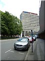
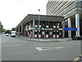
Looking across the A33 to Capella House
Image: © Basher Eyre
Taken: 23 Jun 2011
0.02 miles
4
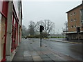
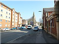
Cook Street in early March
Taken from St Mary's Street.
Image: © Basher Eyre
Taken: 4 Mar 2011
0.04 miles
5
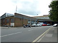
Looking along Houndwell towards the A33
Image: © Basher Eyre
Taken: 23 Jun 2011
0.04 miles
6
The Royal Oak
At the junction of the A33 with Houndwell Place
Image: © Basher Eyre
Taken: 23 Jun 2011
0.04 miles
7
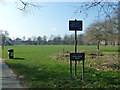
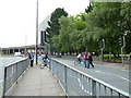
Southampton's splendid parks (48)
Eastern entrance to Hoglands Park.
Image: © Basher Eyre
Taken: 4 Mar 2011
0.05 miles
10
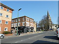
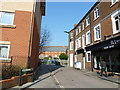
Looking north-eastwards up St Mary's Street
Image: © Basher Eyre
Taken: 4 Mar 2011
0.06 miles