IMAGES TAKEN NEAR TO
St. Marys Place, SOUTHAMPTON, SO14 1AZ
Introduction
This page details the photographs taken nearby to St. Marys Place, SO14 1AZ by members of the Geograph project.
The Geograph project started in 2005 with the aim of publishing, organising and preserving representative images for every square kilometre of Great Britain, Ireland and the Isle of Man.

There are currently over 7.5m images from over14,400 individuals and you can help contribute to the project by visiting https://www.geograph.org.uk
Image Map
Images are licensed for reuse under creativecommons.org/licenses/by-sa/2.0
Notes
- Clicking on the map will re-center to the selected point.
- The higher the marker number, the further away the image location is from the centre of the postcode.
Image Listing (336 Images Found)
Images are licensed for reuse under creativecommons.org/licenses/by-sa/2.0
Image
Details
Distance
1
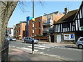
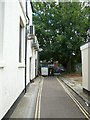
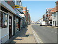
Looking from Cumberland Street into St Mary Street
Image: © Basher Eyre
Taken: 23 Jun 2011
0.02 miles
2
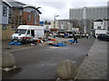
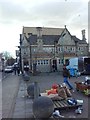
Kingsland Market
From Kingsway/South Front junction.
Image: © Stanley Howe
Taken: 18 Feb 2010
0.03 miles
4
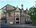
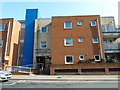
Southampton Buddhist Centre
In a former public house on St Mary Street.
Image: © JThomas
Taken: 27 Apr 2022
0.03 miles
8
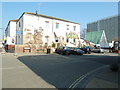
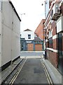
Modern wall painting at the junction of St Mary's and James Streets
Image: © Basher Eyre
Taken: 4 Mar 2011
0.04 miles