IMAGES TAKEN NEAR TO
Dukes Road, SOUTHAMPTON, SO14 0SQ
Introduction
This page details the photographs taken nearby to Dukes Road, SO14 0SQ by members of the Geograph project.
The Geograph project started in 2005 with the aim of publishing, organising and preserving representative images for every square kilometre of Great Britain, Ireland and the Isle of Man.

There are currently over 7.5m images from over14,400 individuals and you can help contribute to the project by visiting https://www.geograph.org.uk
Image Map
Images are licensed for reuse under creativecommons.org/licenses/by-sa/2.0
Notes
- Clicking on the map will re-center to the selected point.
- The higher the marker number, the further away the image location is from the centre of the postcode.
Image Listing (60 Images Found)
Images are licensed for reuse under creativecommons.org/licenses/by-sa/2.0
Image
Details
Distance
1
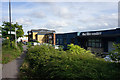
The Life Centre, Southampton
The offices of Life Church in an area of industrial units.
Image: © Bill Boaden
Taken: 29 Sep 2016
0.01 miles
2
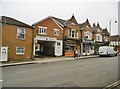
Bevois Mount, Bookshop Alehouse
Micropub opened a year ago on Portswood Road, in the premises of a former bookshop. The remaining books are still on sale! A single room on two levels, with back bar; seating at the bar, or in armchairs left; books in shelves front and left. Cask ales from four breweries were on offer at my visit: Dancing Cows, Purbeck, Urban Island, Vibrant Forest. https://www.facebook.com/BookshopAlehouse/
Image: © Mike Faherty
Taken: 9 Dec 2016
0.12 miles
4
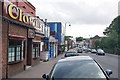
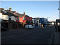
Bevois Valley Road
A small concentration of shops, pubs and food outlets.
Image: © Bill Boaden
Taken: 29 Sep 2016
0.13 miles
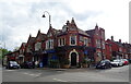
5
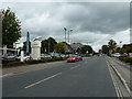
Bevois Valley Road
Clowns and Sobar, with new student accommodation in between. Not necessarily the ideal location for a productive learning environment, but could be fun.
Image: © Hugh Venables
Taken: 14 May 2010
0.14 miles
7
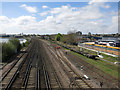
Railway through Southampton
Looking towards central Southampton.
Image: © Hugh Venables
Taken: 5 May 2013
0.15 miles
8
St. Denys, Horseshoe Bridge
Carrying traffic over the Southampton to Waterloo mainline.
Image: © Mike Faherty
Taken: 17 Jul 2010
0.15 miles
9
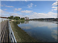
Footpath by the Itchen
Improving the access from St Denys station to St Mary's Stadium.
Image: © Hugh Venables
Taken: 5 May 2013
0.15 miles
10
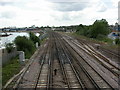
St. Denys, railway lines
Southampton to Waterloo mainline, as seen from Image
Image: © Mike Faherty
Taken: 17 Jul 2010
0.16 miles