IMAGES TAKEN NEAR TO
Nichols Road, SOUTHAMPTON, SO14 0NS
Introduction
This page details the photographs taken nearby to Nichols Road, SO14 0NS by members of the Geograph project.
The Geograph project started in 2005 with the aim of publishing, organising and preserving representative images for every square kilometre of Great Britain, Ireland and the Isle of Man.

There are currently over 7.5m images from over14,400 individuals and you can help contribute to the project by visiting https://www.geograph.org.uk
Image Map
Images are licensed for reuse under creativecommons.org/licenses/by-sa/2.0
Notes
- Clicking on the map will re-center to the selected point.
- The higher the marker number, the further away the image location is from the centre of the postcode.
Image Listing (189 Images Found)
Images are licensed for reuse under creativecommons.org/licenses/by-sa/2.0
Image
Details
Distance
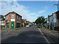
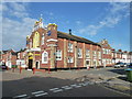
2
Approaching the junction of Derby Road and Nichols Road
Image: © Basher Eyre
Taken: 23 Jun 2011
0.02 miles
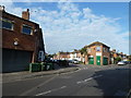
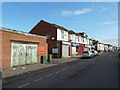
3
Looking from Derby Road into Argyle Road
Image: © Basher Eyre
Taken: 23 Jun 2011
0.04 miles

5
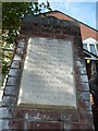
Explanatory text in Brintons Road
Also see http://www.geograph.org.uk/photo/2528639
Image: © Basher Eyre
Taken: 24 Jun 2011
0.05 miles
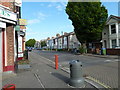
6
Phonebox at the junction of Brintons and Trinity Roads
Image: © Basher Eyre
Taken: 23 Jun 2011
0.05 miles
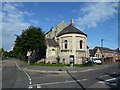
7
Gurdwara on the corner of St Mark's Road and Northbrook Road
Image: © Basher Eyre
Taken: 23 Jun 2011
0.05 miles

10
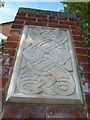
Traditional design on a pillar in Brintons Road
Also see http://www.geograph.org.uk/photo/2528640
Image: © Basher Eyre
Taken: 24 Jun 2011
0.05 miles