IMAGES TAKEN NEAR TO
Empress Park, Empress Road, SOUTHAMPTON, SO14 0JX
Introduction
This page details the photographs taken nearby to Empress Park, Empress Road, SO14 0JX by members of the Geograph project.
The Geograph project started in 2005 with the aim of publishing, organising and preserving representative images for every square kilometre of Great Britain, Ireland and the Isle of Man.

There are currently over 7.5m images from over14,400 individuals and you can help contribute to the project by visiting https://www.geograph.org.uk
Image Map
Images are licensed for reuse under creativecommons.org/licenses/by-sa/2.0
Notes
- Clicking on the map will re-center to the selected point.
- The higher the marker number, the further away the image location is from the centre of the postcode.
Image Listing (73 Images Found)
Images are licensed for reuse under creativecommons.org/licenses/by-sa/2.0
Image
Details
Distance
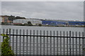
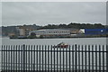
1
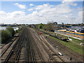
Railway through Southampton
Looking towards central Southampton.
Image: © Hugh Venables
Taken: 5 May 2013
0.08 miles
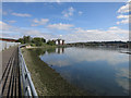
2
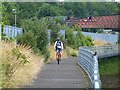
Cyclist on the Itchen Riverside Boardwalk
This boardwalk has been constructed over the foreshore of the Itchen estuary alongside the railway. It affords a traffic-free route for pedestrians and cyclists between the northern suburbs of Southampton and the City centre and St Mary's Stadium, home ground of Southampton Football Club. In the background is Horseshoe Bridge carrying a road over the railway.
Image: © Oliver Dixon
Taken: 29 Jun 2014
0.08 miles
3
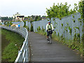
Cyclist and pedestrians on the Itchen Riverside Boardwalk
This boardwalk has been constructed over the foreshore of the Itchen estuary alongside the railway. It affords a traffic-free route for pedestrians and cyclists between the northern suburbs of Southampton and the City centre and St Mary's Stadium, home ground of Southampton Football Club.
Image: © Oliver Dixon
Taken: 29 Jun 2014
0.08 miles
4
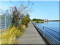
Boardwalk by the Shore
A narrow strip of foreshore between the estuary and the railway has been transformed into a useful route for walking and cycling.
Image: © Des Blenkinsopp
Taken: 23 Aug 2018
0.08 miles
6
Footpath by the Itchen
Improving the access from St Denys station to St Mary's Stadium.
Image: © Hugh Venables
Taken: 5 May 2013
0.10 miles
7
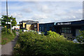
The Life Centre, Southampton
The offices of Life Church in an area of industrial units.
Image: © Bill Boaden
Taken: 29 Sep 2016
0.11 miles
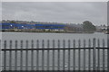
10
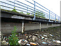
Itchen Riverside Boardwalk
This boardwalk has been constructed over the foreshore of the Itchen estuary alongside the railway. It affords a traffic-free route for pedestrians and cyclists between the northern suburbs of Southampton and the City centre and St Mary's Stadium, home ground of Southampton Football Club. At low tide, the foreshore presents a somewhat unpleasing prospect.
Image: © Oliver Dixon
Taken: 29 Jun 2014
0.13 miles