IMAGES TAKEN NEAR TO
Avon Square, PEWSEY, SN9 6AD
Introduction
This page details the photographs taken nearby to Avon Square, SN9 6AD by members of the Geograph project.
The Geograph project started in 2005 with the aim of publishing, organising and preserving representative images for every square kilometre of Great Britain, Ireland and the Isle of Man.

There are currently over 7.5m images from over14,400 individuals and you can help contribute to the project by visiting https://www.geograph.org.uk
Image Map
Images are licensed for reuse under creativecommons.org/licenses/by-sa/2.0
Notes
- Clicking on the map will re-center to the selected point.
- The higher the marker number, the further away the image location is from the centre of the postcode.
Image Listing (9 Images Found)
Images are licensed for reuse under creativecommons.org/licenses/by-sa/2.0
Image
Details
Distance
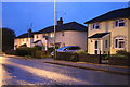
1
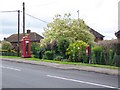
Telephone box, Upavon
A K6 type telephone box beside the A342 on the outskirts of Upavon.
Image: © Maigheach-gheal
Taken: 3 Aug 2009
0.04 miles
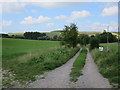
2
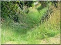
Footpath, Upavon
The footpath allows walkers to leave the A342 and head towards Chisman's Cleeve and Upavon Hill.
Image: © Maigheach-gheal
Taken: 3 Aug 2009
0.05 miles
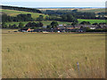
4
Upavon, Wiltshire
Looking over the village of Upavon from the Andover Road.
Image: © Rebecca A Wills
Taken: 12 Mar 2021
0.10 miles
6
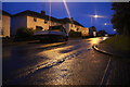
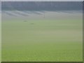
Grassland, Upavon
Looking down on Watson Close in the separate resdidential area off the Andover Road to the south of Upavon's centre.
Image: © Andrew Smith
Taken: 25 Jul 2009
0.17 miles
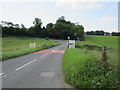
9
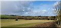
Farmland, Upavon
Looking down to Rowden's Cleeve. The field boundaries shown by the Ordnance Survey no longer apply. There is just one large field stretching up from the A342 to the golf course.
Image: © Andrew Smith
Taken: 8 Apr 2007
0.24 miles