IMAGES TAKEN NEAR TO
Hillside, MARLBOROUGH, SN8 4EF
Introduction
This page details the photographs taken nearby to Hillside, SN8 4EF by members of the Geograph project.
The Geograph project started in 2005 with the aim of publishing, organising and preserving representative images for every square kilometre of Great Britain, Ireland and the Isle of Man.

There are currently over 7.5m images from over14,400 individuals and you can help contribute to the project by visiting https://www.geograph.org.uk
Image Map (Loading...)


Getting Data...Please wait
Leaflet Map data © OpenStreetMap
Images are licensed for reuse under creativecommons.org/licenses/by-sa/2.0
Notes
- Clicking on the map will re-center to the selected point.
- The higher the marker number, the further away the image location is from the centre of the postcode.
Image Listing (48 Images Found)
Images are licensed for reuse under creativecommons.org/licenses/by-sa/2.0
Image
Details
Distance
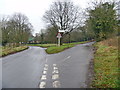
1

View from the bridleway
Looking down the slope towards the properties of Ryles Lane.
Image: © Michael Dibb
Taken: 23 Dec 2017
0.04 miles
2
![Lockeridge houses [2]](https://s1.geograph.org.uk/geophotos/05/66/05/5660557_c815e9d8_120x120.jpg)
Lockeridge houses [2]
Dene Cottage is an 18th century cottage with a later extension to the left and is in the process of being re-thatched. The cottage is listed, grade II, with details at: https://www.historicengland.org.uk/listing/the-list/list-entry/1365931
Lockeridge has evidence of occupation since the Stone Age including Roman, and the village is in the Domesday Book of 1086. It expanded from a hamlet to a village in the 1870s when Sir Henry Meux sited his estate office yard there. Estate houses, a school and a public house were built at the same time.
Image: © Michael Dibb
Taken: 23 Dec 2017
0.08 miles
3
![Lockeridge houses [4]](https://s0.geograph.org.uk/geophotos/06/35/68/6356840_950ca089_120x120.jpg)
Lockeridge houses [4]
Dene Cottage is an 18th century cottage with a later extension to the left. For a 2017 image of the cottage when it was in the process of being re-thatched see Image The cottage is listed, grade II, with details at: https://historicengland.org.uk/listing/the-list/list-entry/1365931
Lockeridge has evidence of occupation since the Stone Age including Roman, and the village is in the Domesday Book of 1086. It expanded from a hamlet to a village in the 1870s when Sir Henry Meux sited his estate office yard there. Estate houses, a school and a public house were built at the same time.
Image: © Michael Dibb
Taken: 2 Sep 2019
0.08 miles
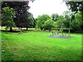
5
![Lockeridge features [1]](https://s1.geograph.org.uk/geophotos/06/35/68/6356837_0b074b9b_120x120.jpg)
Lockeridge features [1]
A small play area on the village green.
Lockeridge has evidence of occupation since the Stone Age including Roman, and the village is in the Domesday Book of 1086. It expanded from a hamlet to a village in the 1870s when Sir Henry Meux sited his estate office yard there. Estate houses, a school and a public house were built at the same time.
Image: © Michael Dibb
Taken: 2 Sep 2019
0.08 miles
6
![Lockeridge houses [7]](https://s1.geograph.org.uk/geophotos/06/35/68/6356865_19dec0d4_120x120.jpg)
Lockeridge houses [7]
Dene View was originally three cottages, now one house. Probably built in the 18th century with a 20th century extension at the rear. Listed, grade II, with details at: https://historicengland.org.uk/listing/the-list/list-entry/1182869
Lockeridge has evidence of occupation since the Stone Age including Roman, and the village is in the Domesday Book of 1086. It expanded from a hamlet to a village in the 1870s when Sir Henry Meux sited his estate office yard there. Estate houses, a school and a public house were built at the same time.
Image: © Michael Dibb
Taken: 2 Sep 2019
0.09 miles
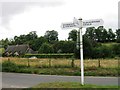
7
Village green
The road forks on the edge of the village of Lockeridge. Left to Fyfield and the A4, right to Manton and Marlborough. The villagers have decorated their tree on the green for Christmas.
Image: © Michael Dibb
Taken: 22 Dec 2014
0.09 miles
9
![Lockeridge houses [6]](https://s0.geograph.org.uk/geophotos/06/35/68/6356864_ddcd652f_120x120.jpg)
Lockeridge houses [6]
The middle three bays of Dene House are 17th century. The two bays to the right are early 19th century, the two to the left are circa 1910. Some older internal features have recently been built in. Listed, grade II, with details at: https://historicengland.org.uk/listing/the-list/list-entry/1182840
Lockeridge has evidence of occupation since the Stone Age including Roman, and the village is in the Domesday Book of 1086. It expanded from a hamlet to a village in the 1870s when Sir Henry Meux sited his estate office yard there. Estate houses, a school and a public house were built at the same time.
Image: © Michael Dibb
Taken: 2 Sep 2019
0.11 miles
10
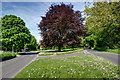
Lockeridge
The area between the two lanes is a small play area.
Image: © Doug Lee
Taken: 2 Jun 2013
0.11 miles