IMAGES TAKEN NEAR TO
Granham Hill, MARLBOROUGH, SN8 4DG
Introduction
This page details the photographs taken nearby to Granham Hill, SN8 4DG by members of the Geograph project.
The Geograph project started in 2005 with the aim of publishing, organising and preserving representative images for every square kilometre of Great Britain, Ireland and the Isle of Man.

There are currently over 7.5m images from over14,400 individuals and you can help contribute to the project by visiting https://www.geograph.org.uk
Image Map
Images are licensed for reuse under creativecommons.org/licenses/by-sa/2.0
Notes
- Clicking on the map will re-center to the selected point.
- The higher the marker number, the further away the image location is from the centre of the postcode.
Image Listing (256 Images Found)
Images are licensed for reuse under creativecommons.org/licenses/by-sa/2.0
Image
Details
Distance
1
![Marlborough features [5]](https://s1.geograph.org.uk/geophotos/05/33/54/5335437_a292caea_120x120.jpg)
Marlborough features [5]
Alongside Graham Close this site is being redeveloped. It was the site of a Citroen motor dealership.
Marlborough is a market town on the Old Bath Road once the main road from London to Bath. The twice-weekly market is sited in High Street, one of the widest in England, lined on both sides with fine listed buildings of which the town has almost 300. There is evidence of local settlement from every period from the prehistoric to the present day. The town is home to the renowned Marlborough College. The River Kennet flows through the town.
Image: © Michael Dibb
Taken: 28 Mar 2017
0.04 miles
2
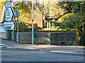
Pillbox, George Lane, Marlborough
This pillbox is on the corner of George Lane and Pewsey Road and was part of the GHQ 'Blue' stop line installed along the line from Reading to Melksham in 1940 to act as a line of resistance against German forces which were expected to invade in the early years of the second world war. It is one of several pillboxes in the town most of which have long since been removed. For another view see Image
Image: © Brian Robert Marshall
Taken: 11 Nov 2012
0.05 miles
3
![Marlborough ways [7]](https://s2.geograph.org.uk/geophotos/05/33/54/5335446_45b9fad6_120x120.jpg)
Marlborough ways [7]
From the A345 Pewsey Road, a bridleway runs through the grounds of Marlborough College to Preshute House. Some modern steeds are making use of the way for parking.
Marlborough is a market town on the Old Bath Road once the main road from London to Bath. The twice-weekly market is sited in High Street, one of the widest in England, lined on both sides with fine listed buildings of which the town has almost 300. There is evidence of local settlement from every period from the prehistoric to the present day. The town is home to the renowned Marlborough College. The River Kennet flows through the town.
Image: © Michael Dibb
Taken: 28 Mar 2017
0.05 miles
4
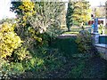
Rear of pillbox, George Lane, Marlborough
The pillbox is hard to spot as it seems to have sunk somewhat in the softish ground on the banks of the River Kennet. It was part of the GHQ 'Blue' stop line installed along the line from Reading to Melksham in 1940 to act as a line of resistance against German forces which were expected to invade in the early years of the second world war. It is one of several pillboxes in the town most of which have long since been removed. For another view see Image
Image: © Brian Robert Marshall
Taken: 11 Nov 2012
0.05 miles
5
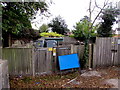
Cowbridge electricity substation, Marlborough
The SSE Power Distribution electricity substation, identifier COWBRIDGE 1340, is set back from the corner of Pewsey Road and George Lane in a wooden enclosure on a bank of the River Kennet.
Image: © Jaggery
Taken: 14 Oct 2017
0.05 miles
6
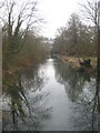
The River Kennet at Marlborough
Looking downstream from Pewsey Road Bridge.
Image: © Rod Allday
Taken: 6 Mar 2013
0.07 miles
7
![Gently flows the Kennet [6]](https://s0.geograph.org.uk/geophotos/05/33/55/5335504_6fb9e82f_120x120.jpg)
Gently flows the Kennet [6]
The River Kennet seen from the bridge that carries the A345 Pewsey Road. Here looking downstream.
Marlborough is a market town on the Old Bath Road once the main road from London to Bath. The twice-weekly market is sited in High Street, one of the widest in England, lined on both sides with fine listed buildings of which the town has almost 300. There is evidence of local settlement from every period from the prehistoric to the present day. The town is home to the renowned Marlborough College. The River Kennet flows through the town.
Image: © Michael Dibb
Taken: 28 Mar 2017
0.07 miles
8

River Kennet, Marlborough
This is a downstream view of the river as it heads away from the bridge over it on Pewsey Road.
Image: © Brian Robert Marshall
Taken: 11 Nov 2012
0.07 miles
9
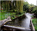
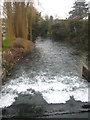
Weir across the River Kennet, Marlborough
Below Pewsey Road Bridge. The railings are at the edge of a Thames Water river monitoring station. http://www.geograph.org.uk/photo/5576685
Image: © Jaggery
Taken: 14 Oct 2017
0.07 miles
10
The River Kennet upstream from Pewsey Road Bridge in Marlborough
Passing the grounds of Marlborough College on the right.
Image: © Rod Allday
Taken: 6 Mar 2013
0.07 miles