IMAGES TAKEN NEAR TO
Taskers Lane, MARLBOROUGH, SN8 3TQ
Introduction
This page details the photographs taken nearby to Taskers Lane, SN8 3TQ by members of the Geograph project.
The Geograph project started in 2005 with the aim of publishing, organising and preserving representative images for every square kilometre of Great Britain, Ireland and the Isle of Man.

There are currently over 7.5m images from over14,400 individuals and you can help contribute to the project by visiting https://www.geograph.org.uk
Image Map
Images are licensed for reuse under creativecommons.org/licenses/by-sa/2.0
Notes
- Clicking on the map will re-center to the selected point.
- The higher the marker number, the further away the image location is from the centre of the postcode.
Image Listing (75 Images Found)
Images are licensed for reuse under creativecommons.org/licenses/by-sa/2.0
Image
Details
Distance
1
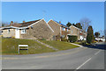
Taskers Lane, Burbage
Burbage is an ancient village, but most of the housing is recent.
Compare the current map with this one http://www.archiuk.com/cgi-bin/build_nls_historic_map.pl?search_location=,%20Burbage,%20Wiltshire&latitude=51.347657&longitude=-1.685503&[email protected] to see how much new infill has been built.
Image: © Des Blenkinsopp
Taken: 27 Feb 2019
0.08 miles
2
![Burbage houses [11]](https://s0.geograph.org.uk/geophotos/07/39/38/7393876_6f7365da_120x120.jpg)
Burbage houses [11]
Number 103 High Street was built in the 17th century. Timber framed, and later encased in painted brick under a thatch roof. There are 3 bays with a small rear wing on the left. Some framing and original internal features and fittings remain. Listed, grade II, with details at: https://historicengland.org.uk/listing/the-list/list-entry/1035915
Burbage is a village in the Vale of Pewsey, Wiltshire, it lies about 5½ miles southeast of Marlborough and some 15½ miles west of Newbury. The narrow village High Street was the main north to south road from Marlborough to Andover (A346) until a bypass was built to the west in 1991. Settlement can be traced back to the Neolithic period, and Bronze Age artefacts have been found. Burbage is now essentially a commuter village.
Image: © Michael Dibb
Taken: 23 Jan 2023
0.08 miles
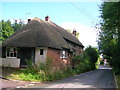
3
![Burbage buildings [3]](https://s1.geograph.org.uk/geophotos/07/39/38/7393869_7d308b8a_120x120.jpg)
Burbage buildings [3]
Now a private house, this Wesleyan Methodist church, number 81 High Street, was built in 1907 and replaced an 1822 chapel at Eastcourt. The church closed in 1996. Constructed of red brick with ashlar dressings under a slate roof.
Burbage is a village in the Vale of Pewsey, Wiltshire, it lies about 5½ miles southeast of Marlborough and some 15½ miles west of Newbury. The narrow village High Street was the main north to south road from Marlborough to Andover (A346) until a bypass was built to the west in 1991. Settlement can be traced back to the Neolithic period, and Bronze Age artefacts have been found. Burbage is now essentially a commuter village.
Image: © Michael Dibb
Taken: 23 Jan 2023
0.09 miles
5
![Burbage houses [15]](https://s2.geograph.org.uk/geophotos/07/39/45/7394594_932b11b2_120x120.jpg)
Burbage houses [15]
Number 114 High Street was built in the late 16th century. Timber framed with brick nogging under a thatch roof. Three bays, the left bay is a later extension with a brick lower section and timber framed above. The two original bays have the upper floor carried on pegged wall rails. Listed, grade II, with details at: https://historicengland.org.uk/listing/the-list/list-entry/1035921
Burbage is a village in the Vale of Pewsey, Wiltshire, it lies about 5½ miles southeast of Marlborough and some 15½ miles west of Newbury. The narrow village High Street was the main north to south road from Marlborough to Andover (A346) until a bypass was built to the west in 1991. Settlement can be traced back to the Neolithic period, and Bronze Age artefacts have been found. Burbage is now essentially a commuter village.
Image: © Michael Dibb
Taken: 23 Jan 2023
0.09 miles
6
![Burbage houses [12]](https://s3.geograph.org.uk/geophotos/07/39/45/7394571_15e5acff_120x120.jpg)
Burbage houses [12]
Wayside, number 104 High Street, and number 106 High Street, are a former house and shop, recently much altered. Built to a 'L' plan with the section on the left, gable end to the street being the former shop. Probably 17th century, timber framed and rendered under a thatch roof. Listed, grade II, with details at: https://historicengland.org.uk/listing/the-list/list-entry/1364601
Burbage is a village in the Vale of Pewsey, Wiltshire, it lies about 5½ miles southeast of Marlborough and some 15½ miles west of Newbury. The narrow village High Street was the main north to south road from Marlborough to Andover (A346) until a bypass was built to the west in 1991. Settlement can be traced back to the Neolithic period, and Bronze Age artefacts have been found. Burbage is now essentially a commuter village.
Image: © Michael Dibb
Taken: 23 Jan 2023
0.09 miles
7
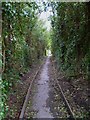
The Orange Way in Wiltshire (353)
This pathway leads from the public house to an area of green and then on to Eastcourt.
Image: © Shazz
Taken: 28 Apr 2013
0.10 miles
8
![Burbage houses [13]](https://s2.geograph.org.uk/geophotos/07/39/45/7394586_87f44d3a_120x120.jpg)
Burbage houses [13]
Dove Cottage, number 109 High Street, was built in the 17th century. Timber framed with brick nogging under a thatch roof. The framing is three panels high with straight corner braces. Brick has replaced the framing on the road front. There is a later, lean-to extension. Listed, grade II, with details at: https://historicengland.org.uk/listing/the-list/list-entry/1194468
Burbage is a village in the Vale of Pewsey, Wiltshire, it lies about 5½ miles southeast of Marlborough and some 15½ miles west of Newbury. The narrow village High Street was the main north to south road from Marlborough to Andover (A346) until a bypass was built to the west in 1991. Settlement can be traced back to the Neolithic period, and Bronze Age artefacts have been found. Burbage is now essentially a commuter village.
Image: © Michael Dibb
Taken: 23 Jan 2023
0.10 miles
9
![Burbage ways [1]](https://s1.geograph.org.uk/geophotos/07/39/45/7394577_249bc636_120x120.jpg)
Burbage ways [1]
The village has an extensive network of footpaths between High Street and Eastcote Road. This path, between numbers 109 and 113 High Street leads into that network.
Burbage is a village in the Vale of Pewsey, Wiltshire, it lies about 5½ miles southeast of Marlborough and some 15½ miles west of Newbury. The narrow village High Street was the main north to south road from Marlborough to Andover (A346) until a bypass was built to the west in 1991. Settlement can be traced back to the Neolithic period, and Bronze Age artefacts have been found. Burbage is now essentially a commuter village.
Image: © Michael Dibb
Taken: 23 Jan 2023
0.10 miles
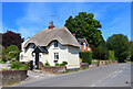
10
Thatched cottages, Burbage
Looking south from the junction of High Street and Smithys Lane.
Image: © Simon Mortimer
Taken: 5 Aug 2012
0.11 miles